IMAGES TAKEN NEAR TO
Water Lane, WATFORD, WD17 2AP
Introduction
This page details the photographs taken nearby to Water Lane, WD17 2AP by members of the Geograph project.
The Geograph project started in 2005 with the aim of publishing, organising and preserving representative images for every square kilometre of Great Britain, Ireland and the Isle of Man.

There are currently over 7.5m images from over14,400 individuals and you can help contribute to the project by visiting https://www.geograph.org.uk
Image Map
Images are licensed for reuse under creativecommons.org/licenses/by-sa/2.0
Notes
- Clicking on the map will re-center to the selected point.
- The higher the marker number, the further away the image location is from the centre of the postcode.
Image Listing (141 Images Found)
Images are licensed for reuse under creativecommons.org/licenses/by-sa/2.0
Image
Details
Distance
1
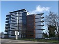
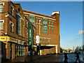
Skylight, Watford
Skylight is a striking building set in the heart of Watford town centre.
On the junction of Water Lane and Beechen Grove (in front).
It has Fifteen apartments which were available for shared ownership (part-buy, part-rent).
See http://www.site-sales.co.uk/pdf/75_Skylight%20Brochure.pdf for more about the apartment brochure from Network Group.
Image: © David Anstiss
Taken: 27 Jan 2013
0.01 miles
2
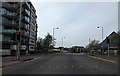
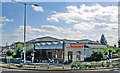
A411 Beechen Grove, Watford
At the junction with Water Lane near Cotswold Outdoor
Image: © Geographer
Taken: 12 Apr 2014
0.03 miles
3
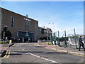
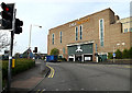
The Harlequin Centre, Beechen Road, Watford
Image: © David Howard
Taken: 6 Sep 2012
0.03 miles
4
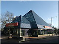
The Pyramid, 161-165 High Street, Watford
This landmark building at the south-eastern end of the High Street started off in life as the Blockbuster Video store, but has had several occupiers since. Including - a computer retailer (PC World?), Knightingales (the soft furnishings company), then Emporio home Link.
In 2010 Cotswold Outdoor took up occupancy.
Compare with Image
Image: © David Anstiss
Taken: 27 Jan 2013
0.04 miles
6
Intu, Watford
On the A411 Beechen Grove (When originally opened this was known as the "Harlequin" Centre.)
http://intu.co.uk/watford
Image: © Geographer
Taken: 12 Apr 2014
0.05 miles
7
Watford High Street station, exterior
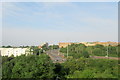
View southward at Lower High Street, towards Bushey, Harrow and London on the railway. Built originally by the LNWR, Watford Junction - Rickmansworth/Croxley Green, LNWR electric trains after 1917: from 1922 LNWR electric trains also ran via Bushey & Oxhey to London (Euston/Broad Street), London Electric (Bakerloo Line) trains from Elephant & Castle having been extended from Queens Park. From 1926-27 the Rickmansworth (Church Street) and Croxley Green branches were electrified, but the Rickmansworth electric service ceased in 3/52, freight from 1/67; a service on the Croxley Green branch lasted until 3/96, but is planned to be revived in the form of the Croxley Link, substituting in part the ex-Metropolitan line from Moor Park to Watford (Met.).
Image: © Ben Brooksbank
Taken: 27 Aug 2009
0.06 miles
10
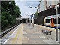
Watford High Street railway station
Opened in 1862 by the Watford & Rickmansworth Railway. View north towards Watford Junction, which is the terminus for local trains from London.
Image: © Nigel Thompson
Taken: 9 Jun 2012
0.07 miles