IMAGES TAKEN NEAR TO
Westland Road, WATFORD, WD17 1QX
Introduction
This page details the photographs taken nearby to Westland Road, WD17 1QX by members of the Geograph project.
The Geograph project started in 2005 with the aim of publishing, organising and preserving representative images for every square kilometre of Great Britain, Ireland and the Isle of Man.

There are currently over 7.5m images from over14,400 individuals and you can help contribute to the project by visiting https://www.geograph.org.uk
Image Map (Loading...)


Getting Data...Please wait
Leaflet Map data © OpenStreetMap
Images are licensed for reuse under creativecommons.org/licenses/by-sa/2.0
Notes
- Clicking on the map will re-center to the selected point.
- The higher the marker number, the further away the image location is from the centre of the postcode.
Image Listing (145 Images Found)
Images are licensed for reuse under creativecommons.org/licenses/by-sa/2.0
Image
Details
Distance
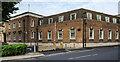
1
Watford Police Station
Shady Lane, Watford.
Image: © Danny P Robinson
Taken: 5 Sep 2006
0.03 miles
2
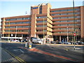
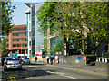
Watford Junction railway station and Iveco House
Most people would know this building as the railway station whose entrance is lower left in the photograph. However most of the structure is Iveco House, a seven storey office block. Iveco (Industrial Vehicles Corporation) http://www.iveco.com/uk/Pages/Home.aspx are commercial vehicle manufacturers, formed in 1975 by the merger of five companies, including Fiat, Lancia, and Magirus-Deutz. Iveco arrived in the UK in 1986 with a joint venture agreement with Ford. This view of the offices was taken from Clarendon Road.
Image: © Nigel Cox
Taken: 16 Feb 2008
0.05 miles
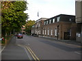
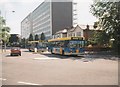
4
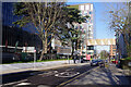
Westland Road Watford
Looking towards Station Road (the station being Watford Junction).
Image: © Danny P Robinson
Taken: 5 Sep 2006
0.05 miles
5

Holiday Inn - Watford Junction
The distinctive Holiday Inn sign stands outside the black building on Clarendon Road, a short walk from Watford Junction station. Until its re-incarnation as a hotel, this was an office block occupied in the early 1990s by various British Rail departments. It was then called Melton House.
Image: © Stephen McKay
Taken: 12 Jan 2022
0.06 miles
6
Clarendon Road, Watford
Clarendon Road nowadays consists primarily of large modern office blocks. It is also the main thoroughfare connecting the town centre with Watford Junction station, which can be seen in the background.
Image: © Stephen McKay
Taken: 19 Apr 2007
0.06 miles
7
Clarendon Road, Watford
Clarendon Road connects Watford town centre with Watford Junction station and is mostly lined with office blocks. In this view the Holiday Inn is on the left; the bridge connecting two parts of the TJX headquarters is a relatively new feature having appeared in 2020.
Image: © Stephen McKay
Taken: 12 Jan 2022
0.08 miles
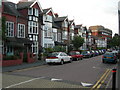
8
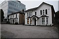
The old and the new
A pair of traditional houses alongside a modern office block on Clarendon Road in Watford.
Image: © Philip Halling
Taken: 6 Sep 2014
0.08 miles
9
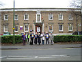
Watford Magistrates' Court
...with picket line!
Image: © Cathy Cox
Taken: 20 Dec 2005
0.09 miles
10
Buses on Clarendon Road, Watford
Network Watford branded Dennis Dart SLF/Plaxton Pointer 3190 of The Shires, then only a few months old, approaches Watford Junction station on its way to Woodside, followed by an older (step entrance) brother.
Image: © Richard Vince
Taken: Unknown
0.09 miles