IMAGES TAKEN NEAR TO
Canterbury Road, WATFORD, WD17 1QT
Introduction
This page details the photographs taken nearby to Canterbury Road, WD17 1QT by members of the Geograph project.
The Geograph project started in 2005 with the aim of publishing, organising and preserving representative images for every square kilometre of Great Britain, Ireland and the Isle of Man.

There are currently over 7.5m images from over14,400 individuals and you can help contribute to the project by visiting https://www.geograph.org.uk
Image Map (Loading...)


Getting Data...Please wait
Leaflet Map data © OpenStreetMap
Images are licensed for reuse under creativecommons.org/licenses/by-sa/2.0
Notes
- Clicking on the map will re-center to the selected point.
- The higher the marker number, the further away the image location is from the centre of the postcode.
Image Listing (141 Images Found)
Images are licensed for reuse under creativecommons.org/licenses/by-sa/2.0
Image
Details
Distance
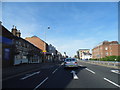
1
Westland Road Watford
Looking towards Station Road (the station being Watford Junction).
Image: © Danny P Robinson
Taken: 5 Sep 2006
0.03 miles

4
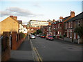
Canterbury Road, Watford.
Near the junction of St Albans Road.
Image: © Danny P Robinson
Taken: 5 Sep 2006
0.07 miles
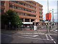
5
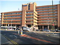
Watford Junction railway station and Iveco House
Most people would know this building as the railway station whose entrance is lower left in the photograph. However most of the structure is Iveco House, a seven storey office block. Iveco (Industrial Vehicles Corporation) http://www.iveco.com/uk/Pages/Home.aspx are commercial vehicle manufacturers, formed in 1975 by the merger of five companies, including Fiat, Lancia, and Magirus-Deutz. Iveco arrived in the UK in 1986 with a joint venture agreement with Ford. This view of the offices was taken from Clarendon Road.
Image: © Nigel Cox
Taken: 16 Feb 2008
0.07 miles
6
Watford Junction Railway Station
Watford Junction is a through station on the Euston Mainline which runs approximately northwest/southeast through the station. It is also the terminus of the Silverlink Metro line from Euston (southeast), the South Central service to Gatwick Airport (southeast) and the Watford Junction - St Albans Abbey line (northwest).
Image: © Chris Hunt
Taken: 3 Jul 2005
0.07 miles
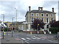
7

Watford: The Flag public house
This attractive building was originally the Clarendon Hotel, built in Station Road in 1860 to serve travellers using the nearby Watford Junction railway station. A comparison with a drawing of the building made in 1862 shows that little has changed in the intervening 146 years! It eventually became a Benskins public house known as The Pennant, but subsequently was rebranded as The Flag and Firkin, finally dropping the Firkin name. For some time the forecourt outside the building, to the left, was used as the bus terminus for the railway station. The building to the left formerly housed the hotel's stables. The building is Grade II listed.
Image: © Nigel Cox
Taken: 16 Feb 2008
0.07 miles
8
The Flag, Watford
The Flag pub in Watford, Hertfordshire. The pub is next door to Watford Junction railway station.
Image: © Malc McDonald
Taken: 23 Jun 2012
0.09 miles
9
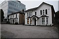
The old and the new
A pair of traditional houses alongside a modern office block on Clarendon Road in Watford.
Image: © Philip Halling
Taken: 6 Sep 2014
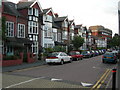
0.09 miles
10
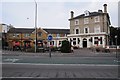
The Flag
The Flag public house is situated next to Watford Junction railway station.
Image: © Philip Halling
Taken: 6 Sep 2014
0.09 miles