IMAGES TAKEN NEAR TO
The Parade, High Street, WATFORD, WD17 1EA
Introduction
This page details the photographs taken nearby to The Parade, High Street, WD17 1EA by members of the Geograph project.
The Geograph project started in 2005 with the aim of publishing, organising and preserving representative images for every square kilometre of Great Britain, Ireland and the Isle of Man.

There are currently over 7.5m images from over14,400 individuals and you can help contribute to the project by visiting https://www.geograph.org.uk
Image Map (Loading...)


Getting Data...Please wait
Leaflet Map data © OpenStreetMap
Images are licensed for reuse under creativecommons.org/licenses/by-sa/2.0
Notes
- Clicking on the map will re-center to the selected point.
- The higher the marker number, the further away the image location is from the centre of the postcode.
Image Listing (185 Images Found)
Images are licensed for reuse under creativecommons.org/licenses/by-sa/2.0
Image
Details
Distance
2
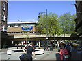
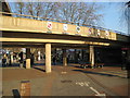
Watford High Street
The High Street in Watford town centre is pedestrianised, apart from a cycle lane. The concrete bridge carries traffic on a ring road over the high street.
Watford is twinned with a number of other towns and cities in other countries. Their coats of arms are displayed on the bridge. More information about Watford's twin towns is on Watford Borough council's website http://www.watford.gov.uk/ccm/navigation/leisure-and-culture/tourism-and-travel/town-twinning/
Image: © Malc McDonald
Taken: 23 Jun 2012
0.01 miles
3
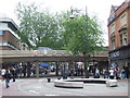
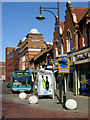
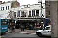
The Parade, Watford
Looking south east towards the High Street. This end of the High Street is the 'café quarter' with numerous pubs, clubs, bars and restaurants.
Image: © Cathy Cox
Taken: 10 Oct 2005
0.03 miles
4
A411 Exchange Road, Watford
At the junction with the A411 Beechen Grove
Image: © Geographer
Taken: 12 Apr 2014
0.04 miles
6
Clarendon Road, Watford
The southern end of Clarendon Road seen from the junction with High Street.
Image: © Stephen McKay
Taken: 19 Apr 2007
0.05 miles
7
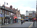
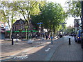
Clarendon Road, Watford
Clarendon Road leads into Watford town centre.
The town centre is part-pedestrianised. The signs either side of the street show that general traffic prohibited from passing through. Buses, taxis and holders of "blue badge" permits are allowed through, while goods delivery vehicles are also permitted at certain times.
Image: © Malc McDonald
Taken: 23 Jun 2012
0.06 miles
8
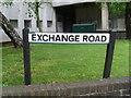
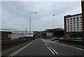
Exchange Road, Watford
This street name is named after the telephone exchange which can be seen behind it. It is now part of the A411 road through Watford.
Image: © David Hillas
Taken: 21 May 2013
0.06 miles
9
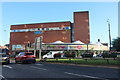
Watford: High Street and the Exchange Road flyover
The High Street is pedestrianized. The flyover was built in 1972 and allows traffic from the A411 Exchange Road to reach Beechen Grove (one-way from left to right in this photograph). The coats of arms of Watford and its five twin towns are on the flyover parapet. They are, from left to right, Mainz, Nanterre, Novgorod, Watford, Pesaro and Wilmington. The twinning with Novgorod, which happened in 1984, met with some local opposition and the forming of the WART group (Watford Against Russian Twinning!).
Image: © Nigel Cox
Taken: 16 Feb 2008
0.06 miles
10
The 'Moon Under Water', High Street, Watford
This is a Wetherspoon's pub. The chain have a policy of no juke-boxes or other music, and there is always real ale available. Almost all the pub names contain the word 'moon'.
Image: © Dr Neil Clifton
Taken: 11 Nov 2007
0.06 miles