IMAGES TAKEN NEAR TO
The Parade, High Street, WATFORD, WD17 1AY
Introduction
This page details the photographs taken nearby to The Parade, High Street, WD17 1AY by members of the Geograph project.
The Geograph project started in 2005 with the aim of publishing, organising and preserving representative images for every square kilometre of Great Britain, Ireland and the Isle of Man.

There are currently over 7.5m images from over14,400 individuals and you can help contribute to the project by visiting https://www.geograph.org.uk
Image Map (Loading...)


Getting Data...Please wait
Leaflet Map data © OpenStreetMap
Images are licensed for reuse under creativecommons.org/licenses/by-sa/2.0
Notes
- Clicking on the map will re-center to the selected point.
- The higher the marker number, the further away the image location is from the centre of the postcode.
Image Listing (137 Images Found)
Images are licensed for reuse under creativecommons.org/licenses/by-sa/2.0
Image
Details
Distance
1
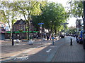
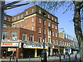
The Parade, Watford
Looking south east towards the High Street. This end of the High Street is the 'café quarter' with numerous pubs, clubs, bars and restaurants.
Image: © Cathy Cox
Taken: 10 Oct 2005
0.02 miles
3
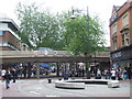
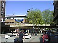
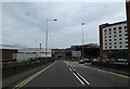
Watford High Street
The High Street in Watford town centre is pedestrianised, apart from a cycle lane. The concrete bridge carries traffic on a ring road over the high street.
Watford is twinned with a number of other towns and cities in other countries. Their coats of arms are displayed on the bridge. More information about Watford's twin towns is on Watford Borough council's website http://www.watford.gov.uk/ccm/navigation/leisure-and-culture/tourism-and-travel/town-twinning/
Image: © Malc McDonald
Taken: 23 Jun 2012
0.04 miles
5
A411 Exchange Road, Watford
At the junction with the A411 Beechen Grove
Image: © Geographer
Taken: 12 Apr 2014
0.05 miles
6
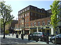
The former Prudential office building on The Parade
Image: © Steve Daniels
Taken: 19 May 2010
0.05 miles
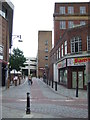
9
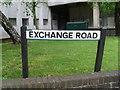
Exchange Road, Watford
This street name is named after the telephone exchange which can be seen behind it. It is now part of the A411 road through Watford.
Image: © David Hillas
Taken: 21 May 2013
0.07 miles
10
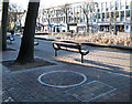
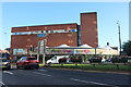
Public Urinal, The Parade, Watford
Yes, this is a urinal. The circular outline in the foreground is the roof of a pop-up urinal, one of two installed in Watford town centre for the purpose of reducing the necessity to use shop doorways after a night on the - er - town. Apparently they rise up at around 8pm on Mondays, Fridays and Saturdays and sink at about 7 or 8am the following morning. I have no idea where the controller with, presumably, a remote is located but the command centre must surely be in contact with the CCTV operators to ensure no-one is standing on the pod when it pops up. My sources tell me that the arrival of these structures has had no discernible effect on the peeing habits of the revellers as, although they are strategically placed close to the main watering holes, they are so discreet (the urinals that is, not the merrymakers) that they are rarely noticed and the few punters who do spot them think they are drinking fountains. Judge for yourself https://www.youtube.com/watch?v=C8iR3pgt37I
On a more serious note, no similar provision has been made for the ladies who still have to find a dark alley for a moment's privacy - not a very safe option.
Image: © Cathy Cox
Taken: 3 Mar 2008
0.07 miles