IMAGES TAKEN NEAR TO
WD1 6TL
Introduction
This page details the photographs taken nearby to WD1 6TL by members of the Geograph project.
The Geograph project started in 2005 with the aim of publishing, organising and preserving representative images for every square kilometre of Great Britain, Ireland and the Isle of Man.

There are currently over 7.5m images from over14,400 individuals and you can help contribute to the project by visiting https://www.geograph.org.uk
Image Map
Images are licensed for reuse under creativecommons.org/licenses/by-sa/2.0
Notes
- Clicking on the map will re-center to the selected point.
- The higher the marker number, the further away the image location is from the centre of the postcode.
Image Listing (6 Images Found)
Images are licensed for reuse under creativecommons.org/licenses/by-sa/2.0
Image
Details
Distance
1
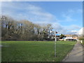
Footpath on the South Oxhey Estate
This footpath leads from Furze Close to Muirfield Road. The edge of Oxhey Woods can be seen on the left, beyond the grass.
Oxhey Woods is the largest Local Nature Reserve (LNR) in Three Rivers District. The character of the woods is varied, created by centuries of management for a variety of woodland products. Prestwick Road and Oxhey Drive divide the woods into three separate areas.
The woods are an important Wildlife Site, notable for the rare Wild Service Tree. Sometimes known as the ‘Chequers Tree’ because of its distinctively patterned bark, the leaves and berries form the LNR logo. Some parts of the LNR are ancient woodland, having been continuously covered by woodland for at least four hundred years, and possibly up to ten thousand years. Wild Service Tree is one of the indicators of ancient woodland. Features such as sunken pathways, earth banks and ditches can also be seen. In the past these earth works often marked boundaries between different land uses and ownership.
The London LOOP passes through Oxhey Woods and the woods are an important resource for the residents of the South Oxhey Estate.
Image: © Marathon
Taken: 30 Jan 2019
0.06 miles
2
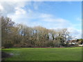
The edge of Oxhey Woods
Oxhey Woods is the largest Local Nature Reserve (LNR) in Three Rivers District. The character of the woods is varied, created by centuries of management for a variety of woodland products. Prestwick Road and Oxhey Drive divide the woods into three separate areas.
The woods are an important Wildlife Site, notable for the rare Wild Service Tree. Sometimes known as the ‘Chequers Tree’ because of its distinctively patterned bark, the leaves and berries form the LNR logo. Some parts of the LNR are ancient woodland, having been continuously covered by woodland for at least four hundred years, and possibly up to ten thousand years. Wild Service Tree is one of the indicators of ancient woodland. Features such as sunken pathways, earth banks and ditches can also be seen. In the past these earth works often marked boundaries between different land uses and ownership.
The London LOOP passes through Oxhey Woods and the woods are an important resource for the residents of the South Oxhey Estate. This is the easternmost edge of the woods, seen from Furze Close on the South Oxhey Estate.
Image: © Marathon
Taken: 30 Jan 2019
0.07 miles
3
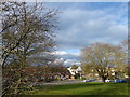
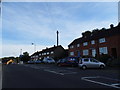
Green on the South Oxhey Estate
This small green is in the angle of Prestwick Road and Little Oxhey Lane. The cars directly ahead are on the mini roundabout where Little Oxhey Lane on the right meets Prestwick Road straight ahead. Another view of it can be seen at https://www.geograph.org.uk/photo/6039637
Image: © Marathon
Taken: 30 Jan 2019
0.22 miles
4
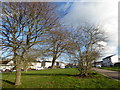
Green on the South Oxhey Estate
This small green is in the angle of Prestwick Road and Little Oxhey Lane, with Bramshaw Gardens on the right. The cars directly ahead are on Little Oxhey Lane.
Image: © Marathon
Taken: 30 Jan 2019
0.23 miles
6
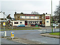
The Dick Whittington, South Oxhey
On Prestwick Road.
Image: © Robin Webster
Taken: 23 Feb 2013
0.24 miles