IMAGES TAKEN NEAR TO
Dinorben Avenue, ST. HELENS, WA9 3UL
Introduction
This page details the photographs taken nearby to Dinorben Avenue, WA9 3UL by members of the Geograph project.
The Geograph project started in 2005 with the aim of publishing, organising and preserving representative images for every square kilometre of Great Britain, Ireland and the Isle of Man.

There are currently over 7.5m images from over14,400 individuals and you can help contribute to the project by visiting https://www.geograph.org.uk
Image Map
Images are licensed for reuse under creativecommons.org/licenses/by-sa/2.0
Notes
- Clicking on the map will re-center to the selected point.
- The higher the marker number, the further away the image location is from the centre of the postcode.
Image Listing (6 Images Found)
Images are licensed for reuse under creativecommons.org/licenses/by-sa/2.0
Image
Details
Distance
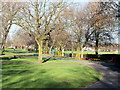
1
Sign at entrance to Sutton Park from Marina Avenue
Image: © Gary Rogers
Taken: 23 Feb 2016
0.09 miles
3
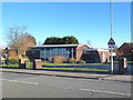
Methodist Church, New Street, Sutton
Banner reads "150 years of Methodism in Sutton"
Image: © Gary Rogers
Taken: 23 Feb 2016
0.17 miles
4
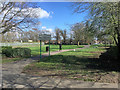
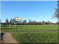
St Helens, Sutton Park
Sutton Park is situated between Robins Lane, Marshalls Cross Road and Marina Avenue and is the oldest public park in Sutton. More information about the park and its history can be found at https://www.suttonbeauty.org.uk/beauty/suttonpark/
Image: © David Dixon
Taken: 24 Mar 2019
0.18 miles
5
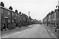
A back street in the Peasley Cross area, near St Helens
Another view of grim North Country side street. [I cannot be more precise about its location. Perhaps someone else knew it - nearly 50 years ago?]
Image: © Ben Brooksbank
Taken: 16 Apr 1962
0.19 miles