IMAGES TAKEN NEAR TO
Yarn Close, ST. HELENS, WA9 3GJ
Introduction
This page details the photographs taken nearby to Yarn Close, WA9 3GJ by members of the Geograph project.
The Geograph project started in 2005 with the aim of publishing, organising and preserving representative images for every square kilometre of Great Britain, Ireland and the Isle of Man.

There are currently over 7.5m images from over14,400 individuals and you can help contribute to the project by visiting https://www.geograph.org.uk
Image Map
Images are licensed for reuse under creativecommons.org/licenses/by-sa/2.0
Notes
- Clicking on the map will re-center to the selected point.
- The higher the marker number, the further away the image location is from the centre of the postcode.
Image Listing (9 Images Found)
Images are licensed for reuse under creativecommons.org/licenses/by-sa/2.0
Image
Details
Distance
1
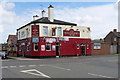
The Boilermaker's Arms
Public house at the corner of Houghton Road and Cecil Street.
Image: © David Dixon
Taken: 24 Mar 2019
0.13 miles
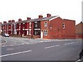
2
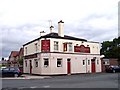
The Boilermaker's Arms
On the corner of Cecil Street and Hoghton Road
Image: © Raymond Knapman
Taken: 7 Aug 2010
0.14 miles
5
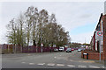
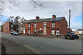
Terraced housing at Moss Nook
The view is at the junction of Watery Lane and Berrys Lane
Image: © Raymond Knapman
Taken: 7 Aug 2010
0.23 miles
6
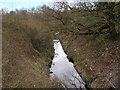
Sutton Brook
Sutton Brook flows throughout Sutton and ultimately into the St Helens/Sankey Canal. The brook has been in existence for hundreds of years and for many years it was the dumping ground for much industrial and chemical waste which gave rise to foul odours for which it became notorious. During the nineteenth century, it was colloquially referred to as the 'Stygian' (ie dark and dismal) Brook and in more recent times it was known to St.Helens folk as 'Stinky' brook (https://www.suttonbeauty.org.uk/beauty/suttonbrook/ Sutton Beauty).
Image: © David Dixon
Taken: 24 Mar 2019
0.25 miles
8
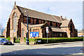
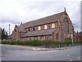
The Church of All Saints, Ellamsbridge Road
All Saints’ Church at Sutton is an Anglican parish church built between 1891 and 1893. It is a Grade II listed building (Historic England List Entry Number: 1260566 https://historicengland.org.uk/listing/the-list/list-entry/1260566 ).
Image: © David Dixon
Taken: 24 Mar 2019
0.25 miles