IMAGES TAKEN NEAR TO
Reynolds Avenue, ST. HELENS, WA9 2QL
Introduction
This page details the photographs taken nearby to Reynolds Avenue, WA9 2QL by members of the Geograph project.
The Geograph project started in 2005 with the aim of publishing, organising and preserving representative images for every square kilometre of Great Britain, Ireland and the Isle of Man.

There are currently over 7.5m images from over14,400 individuals and you can help contribute to the project by visiting https://www.geograph.org.uk
Image Map
Images are licensed for reuse under creativecommons.org/licenses/by-sa/2.0
Notes
- Clicking on the map will re-center to the selected point.
- The higher the marker number, the further away the image location is from the centre of the postcode.
Image Listing (10 Images Found)
Images are licensed for reuse under creativecommons.org/licenses/by-sa/2.0
Image
Details
Distance
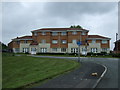
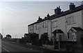
1
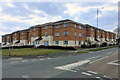
Ashton's Green
Block of housing at the corner of Waring Avenue and Newton Road.
Image: © David Dixon
Taken: 12 Apr 2019
0.19 miles
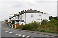
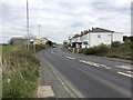
3
Newton Road (A572)
Heading north west towards St Helens.
Image: © JThomas
Taken: 5 Jun 2014
0.20 miles
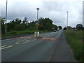
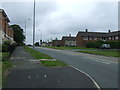
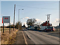
6
Newton Road/Pennington Lane
Newton Road becomes Pennington Lane when it enters Warrington.
Image: © David Dixon
Taken: 12 Apr 2019
0.20 miles
7
Newton Road (A572)
Heading north west towards St Helens.
Image: © JThomas
Taken: 5 Jun 2014
0.20 miles
10
Sutton Leach, Broad Lane
Arriva North West 2489, CX54 DKD, a VDL SB120 single decker, pauses on Broad Lane on route 329 towards St Helens.
Image: © David Dixon
Taken: 2 Feb 2013
0.24 miles