IMAGES TAKEN NEAR TO
Ashtons Green Drive, ST. HELENS, WA9 2AS
Introduction
This page details the photographs taken nearby to Ashtons Green Drive, WA9 2AS by members of the Geograph project.
The Geograph project started in 2005 with the aim of publishing, organising and preserving representative images for every square kilometre of Great Britain, Ireland and the Isle of Man.

There are currently over 7.5m images from over14,400 individuals and you can help contribute to the project by visiting https://www.geograph.org.uk
Image Map
Images are licensed for reuse under creativecommons.org/licenses/by-sa/2.0
Notes
- Clicking on the map will re-center to the selected point.
- The higher the marker number, the further away the image location is from the centre of the postcode.
Image Listing (11 Images Found)
Images are licensed for reuse under creativecommons.org/licenses/by-sa/2.0
Image
Details
Distance
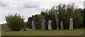
2
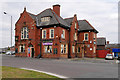
The Horseshoe
Large pub on the outskirts of St Helens.
Image: © David Dixon
Taken: 12 Apr 2019
0.17 miles
3
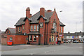
The Horseshoe, Ashton's Green
Large pub on the outskirts of St Helens.
Image: © David Dixon
Taken: 12 Apr 2019
0.17 miles

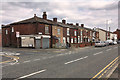
5
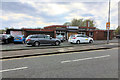
Parr Sports and Community Centre
Derbyshire Hill Lane.
Image: © David Dixon
Taken: 12 Apr 2019
0.18 miles
6
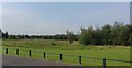
Common Land off Derbyshire Hill Road
Image: © Anthony Parkes
Taken: 20 Jun 2017
0.20 miles
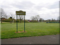
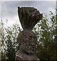
9
"The Green Man" art installation on The Duckeries in Parr
This is part of The Mersey Forest http://merseyforest.org.uk/pages/us_overview.asp
At least part of this open space was formerly Ashtons Green Colliery
Image: © Ian Greig
Taken: 7 Jul 2011
0.23 miles
10
Little children in Parr go to bed when their mummies tell them
Image: © Ian Greig
Taken: 7 Jul 2011
0.24 miles