IMAGES TAKEN NEAR TO
O'Brien Grove, ST. HELENS, WA9 1RB
Introduction
This page details the photographs taken nearby to O'Brien Grove, WA9 1RB by members of the Geograph project.
The Geograph project started in 2005 with the aim of publishing, organising and preserving representative images for every square kilometre of Great Britain, Ireland and the Isle of Man.

There are currently over 7.5m images from over14,400 individuals and you can help contribute to the project by visiting https://www.geograph.org.uk
Image Map
Images are licensed for reuse under creativecommons.org/licenses/by-sa/2.0
Notes
- Clicking on the map will re-center to the selected point.
- The higher the marker number, the further away the image location is from the centre of the postcode.
Image Listing (15 Images Found)
Images are licensed for reuse under creativecommons.org/licenses/by-sa/2.0
Image
Details
Distance
1
New housing, Boardmans Lane
New apartments nearing completion just beyond Parr Bridge, as seen across the dismal overgrown banks of the St Helens Canal/Sutton Brook.
Image: © Chris Denny
Taken: 23 Apr 2010
0.15 miles
3
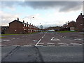
Path between Boardmans Lane and Blackbrook Road
Image: © Gary Rogers
Taken: 29 Apr 2017
0.18 miles
5
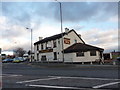
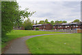
Princess Royal, Park Road, St Helens
Image: © Alexander P Kapp
Taken: 26 Jan 2011
0.18 miles

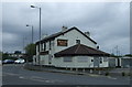
7
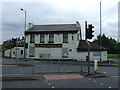
The Princess Royal pub
Currently boarded up (June 2014).
Image: © JThomas
Taken: 5 Jun 2014
0.20 miles
8
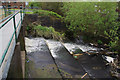
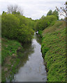
Weir on St Helens Canal near Blackbrook Road
Image: © Gary Rogers
Taken: 29 Apr 2017
0.20 miles
9
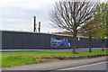
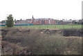
Site of new Lidl Supermarket, Blackbrook Road, Parr
Image: © Gary Rogers
Taken: 29 Apr 2017
0.20 miles
10
The Princess Royal pub
Currently boarded up (June 2014).
Image: © JThomas
Taken: 5 Jun 2014
0.21 miles