IMAGES TAKEN NEAR TO
Davies Street, ST. HELENS, WA9 1FL
Introduction
This page details the photographs taken nearby to Davies Street, WA9 1FL by members of the Geograph project.
The Geograph project started in 2005 with the aim of publishing, organising and preserving representative images for every square kilometre of Great Britain, Ireland and the Isle of Man.

There are currently over 7.5m images from over14,400 individuals and you can help contribute to the project by visiting https://www.geograph.org.uk
Image Map
Images are licensed for reuse under creativecommons.org/licenses/by-sa/2.0
Notes
- Clicking on the map will re-center to the selected point.
- The higher the marker number, the further away the image location is from the centre of the postcode.
Image Listing (27 Images Found)
Images are licensed for reuse under creativecommons.org/licenses/by-sa/2.0
Image
Details
Distance
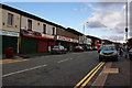
1
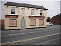
Last orders called
The Furnacemans Arms, Pocket Nook Street, one of many closed pubs in the area.
Image: © Chris Denny
Taken: 23 Apr 2010
0.03 miles
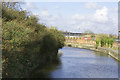
3
Site of railway swing bridge at Pocket Nook
The bridge swivelled on the Eastern bank of the Sankey Canal
Image: © Raymond Knapman
Taken: 3 Aug 2009
0.14 miles
6
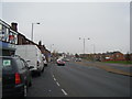
Higher Parr Street
The always busy Fingerpost shopping area is full of the type of shops regrettably becoming increasingly rare in our bland towns.
Image: © Chris Denny
Taken: 23 Apr 2010
0.18 miles
7
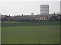
Gasholder, St Helens
Visible from much of the town and seen here from below the old railway embankment to the south of the Ravenhead Greenway, with a primary school in the foreground.
Image: © Chris Denny
Taken: 23 Apr 2010
0.18 miles
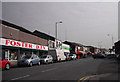
8
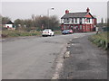
The lone Star
The Star Inn on Merton Bank Road, in splendid isolation, with many of the local houses having been cleared over the years. Its immediate neighbours are a scrapyard and a primary school.
Image: © Chris Denny
Taken: 23 Apr 2010
0.18 miles
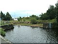
9
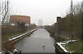
Restored section of the Sankey Canal
Various sections of the Sankey Canal have been restored over the past twenty years. This is one of the earlier restorations. It was carried out when the St. Helens' Technology Campus (right) was built, and provides a pleasant ambience for the staff there... though not all might enjoy the nostalgia of seeing one of the last, genuine gas-works walls in the region.
Image: © David Long
Taken: 8 Feb 2007
0.19 miles