IMAGES TAKEN NEAR TO
Robinson Place, ST. HELENS, WA9 1BJ
Introduction
This page details the photographs taken nearby to Robinson Place, WA9 1BJ by members of the Geograph project.
The Geograph project started in 2005 with the aim of publishing, organising and preserving representative images for every square kilometre of Great Britain, Ireland and the Isle of Man.

There are currently over 7.5m images from over14,400 individuals and you can help contribute to the project by visiting https://www.geograph.org.uk
Image Map
Images are licensed for reuse under creativecommons.org/licenses/by-sa/2.0
Notes
- Clicking on the map will re-center to the selected point.
- The higher the marker number, the further away the image location is from the centre of the postcode.
Image Listing (17 Images Found)
Images are licensed for reuse under creativecommons.org/licenses/by-sa/2.0
Image
Details
Distance
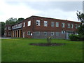
4
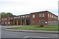
St Helens fire station
St Helens fire station, Parr Stocks Road, St Helens, Merseyside.
Image: © Kevin Hale
Taken: 23 Oct 2006
0.11 miles
5
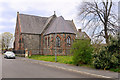
Holy Trinity Church, Parr Mount, St Helens
Architects W&J Jay, 1857. Chancel added 1885. Faced with copper slag blocks and cement, with walls infilled with industrial rubble.
Image: © S Parish
Taken: 9 Oct 2005
0.14 miles
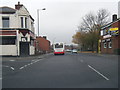
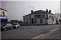
6
The Oddfellows Arms pub
On Parr Stocks Road.
Image: © JThomas
Taken: 5 Jun 2014
0.18 miles
7
Terminally named pub, Fingerpost
In view of the number of pub closures in the town, calling one 'Last Orders' might be making it a hostage to fortune.
Image: © Chris Denny
Taken: 23 Apr 2010
0.18 miles
8
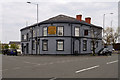
Last Orders - Finger Post Hotel
This former pub on Higher Parr Street appears to now be the Naga Spice Indian restaurant. See Image] for a view taken in 2010.
Image: © David Dixon
Taken: 12 Apr 2019
0.19 miles
9
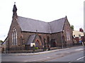
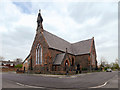
Church of the Holy Trinity, Parr Mount
Holy Trinity Church was built in 1857 in the “Early English “style”, simple with a layout based on the typical rural church of the 13th Century. The church was built to a T-shaped plan. There were galleries at the west end and in each transept, and the building could seat 616 people. In 1886 the church was extended and reordered in order to accommodate changes in the style of Anglican worship in the late Victorian era.
Parr/Fingerpost was not a wealthy area so a cheap and plentiful local material was used for the outer face of the solid walls: slag from the local copper works. This very hard, glassy material (a waste product) was used locally for building although its use in building declined and was almost extinct by the 1880s; very few slag buildings survive today.
The church is a Grade II listed building (Historic England List Entry Number: 1199308 https://historicengland.org.uk/listing/the-list/list-entry/1199308 ).
Image: © David Dixon
Taken: 12 Apr 2019
0.19 miles
10
Holy Trinity Church, Parr Mount
Holy Trinity Church was built in 1857 in the “Early English “style”, simple with a layout based on the typical rural church of the 13th Century. The church was built to a T-shaped plan. There were galleries at the west end and in each transept, and the building could seat 616 people. In 1886 the church was extended and reordered in order to accommodate changes in the style of Anglican worship in the late Victorian era.
Parr/Fingerpost was not a wealthy area so a cheap and plentiful local material was used for the outer face of the solid walls: slag from the local copper works. This very hard, glassy material (a waste product) was used locally for building although its use in building declined and was almost extinct by the 1880s; very few slag buildings survive today.
The church is a Grade II listed building (Historic England List Entry Number: 1199308 https://historicengland.org.uk/listing/the-list/list-entry/1199308 ).
Image: © David Dixon
Taken: 12 Apr 2019
0.20 miles