IMAGES TAKEN NEAR TO
McCulloch Street, ST. HELENS, WA9 1AJ
Introduction
This page details the photographs taken nearby to McCulloch Street, WA9 1AJ by members of the Geograph project.
The Geograph project started in 2005 with the aim of publishing, organising and preserving representative images for every square kilometre of Great Britain, Ireland and the Isle of Man.

There are currently over 7.5m images from over14,400 individuals and you can help contribute to the project by visiting https://www.geograph.org.uk
Image Map
Images are licensed for reuse under creativecommons.org/licenses/by-sa/2.0
Notes
- Clicking on the map will re-center to the selected point.
- The higher the marker number, the further away the image location is from the centre of the postcode.
Image Listing (31 Images Found)
Images are licensed for reuse under creativecommons.org/licenses/by-sa/2.0
Image
Details
Distance
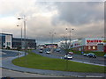
3
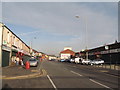
Council depot and trading estate
A view of the Hardshaw St depot and part of a trading estate. The gasholder on the left used to be one of a pair straddling the main road into St Helens from the south and is a landmark for miles around. Its partner has long gone, as has the status of the road they straddled, replaced by a 'Linkway.'
Image: © Chris Denny
Taken: 20 Apr 2010
0.10 miles
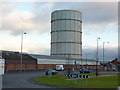
4
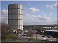
Demolishing the gasholder
Work in progress on dismantling the second of St Helens two former giant gasholders which were located either side of Peasley Cross Road. The first went many years ago while this one was taken down over the summer and autumn of 2012,
Image: © Chris Denny
Taken: 27 Sep 2012
0.11 miles
6
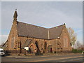
Holy Trinity Church, Fingerpost
It is indeed sad news that Holy Trinity Church in Fingerpost is likely to be closed and demolished. The way in which it was constructed using copper slag blocks, cement and industrial rubble is probably one of the reasons it is so costly to maintain.
Image: © Sue Adair
Taken: 4 Nov 2007
0.12 miles
7
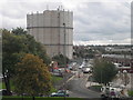
Gas holder between Peasley Cross Lane and Jackson Street
Image: © Alexander P Kapp
Taken: 26 Jan 2011
0.13 miles
9
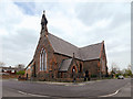
Holy Trinity Church, Parr Mount
Holy Trinity Church was built in 1857 in the “Early English “style”, simple with a layout based on the typical rural church of the 13th Century. The church was built to a T-shaped plan. There were galleries at the west end and in each transept, and the building could seat 616 people. In 1886 the church was extended and reordered in order to accommodate changes in the style of Anglican worship in the late Victorian era.
Parr/Fingerpost was not a wealthy area so a cheap and plentiful local material was used for the outer face of the solid walls: slag from the local copper works. This very hard, glassy material (a waste product) was used locally for building although its use in building declined and was almost extinct by the 1880s; very few slag buildings survive today.
The church is a Grade II listed building (Historic England List Entry Number: 1199308 https://historicengland.org.uk/listing/the-list/list-entry/1199308 ).
Image: © David Dixon
Taken: 12 Apr 2019
0.13 miles
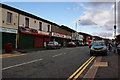
10
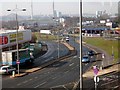
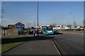
Parr Street, St. Helens
Parr Street is the main road into the town from the east. This view, at the junction with Corporation Street, shows some of the remaining industrial infrastructure to the town behind the roundabouts and the flatpack sheds.
Image: © Chris Denny
Taken: 2 Mar 2010
0.13 miles