IMAGES TAKEN NEAR TO
Hall Lane, WIDNES, WA8 5DW
Introduction
This page details the photographs taken nearby to Hall Lane, WA8 5DW by members of the Geograph project.
The Geograph project started in 2005 with the aim of publishing, organising and preserving representative images for every square kilometre of Great Britain, Ireland and the Isle of Man.

There are currently over 7.5m images from over14,400 individuals and you can help contribute to the project by visiting https://www.geograph.org.uk
Image Map
Images are licensed for reuse under creativecommons.org/licenses/by-sa/2.0
Notes
- Clicking on the map will re-center to the selected point.
- The higher the marker number, the further away the image location is from the centre of the postcode.
Image Listing (30 Images Found)
Images are licensed for reuse under creativecommons.org/licenses/by-sa/2.0
Image
Details
Distance
1
Entrance to the Pasture
A park area maintained by Knowsley Council.
Image: © Bill Boaden
Taken: 20 Feb 2015
0.02 miles
2
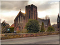
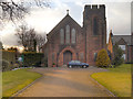
Holy Family Church, Hall Lane, Cronton
Holy Family Roman Catholic Church, on Hall Lane at Cronton was built in 1911.
Image: © David Dixon
Taken: 30 Mar 2013
0.09 miles
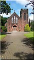
3
Holy Family Roman Catholic Church
The Holy Family Roman Catholic Church in Hall Lane, Cronton was built in 1911.
Image: © Sue Adair
Taken: 13 May 2008
0.09 miles
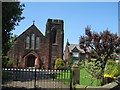
4
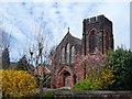
Holy Trinity Church at Cronton
Viewed from the south-east.
Image: © Peter Wood
Taken: 11 Jul 2015
0.10 miles
5
Cronton, Holy Family Church
Holy Family Roman Catholic Church, on Hall Lane at Cronton was built in 1911.
Image: © David Dixon
Taken: 30 Mar 2013
0.10 miles
7
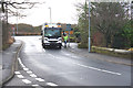
Bin day in Cronton
Now that most local authorities want waste to be separated, bin days don't have quite the same significance.
Image: © Bill Boaden
Taken: 20 Feb 2015
0.14 miles
8
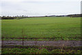
Grassy farmland near Cronton
Wide open fields leading up to the M62 motorway.
Image: © Bill Boaden
Taken: 20 Feb 2015
0.14 miles
9
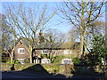
Sunnyside, Cronton
Originally an 18th Century farmhouse in Hall Lane, Cronton, adjacent to Cronton Hall.
Image: © Sue Adair
Taken: 28 Jan 2006
0.14 miles
10
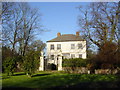
Cronton Hall
The name of the township of Cronton is of Saxon origin meaning 'settlement of crows'. It lies within the parish of Farnworth, 7 miles west of Warrington, 5 miles south of Prescot and 4 miles south of St Helen's. The manor formed part of the ancient Barony of Widnes until about 1250 and its lands passed through a succession of owners until the Wright family eventually became sole owners in the mid seventeenth century. Successive generations of the family lived at Cronton Hall until 1821 when it was sold to Mr Bartholomew Bretherton of Rainhill who enlarged the house and grounds. Cronton Hall is a prime example of the 'Queen Anne' style house and is now the centre of the Town End Conservation Area.
Image: © Sue Adair
Taken: 28 Jan 2006
0.14 miles