IMAGES TAKEN NEAR TO
Skye Close, WIDNES, WA8 3YP
Introduction
This page details the photographs taken nearby to Skye Close, WA8 3YP by members of the Geograph project.
The Geograph project started in 2005 with the aim of publishing, organising and preserving representative images for every square kilometre of Great Britain, Ireland and the Isle of Man.

There are currently over 7.5m images from over14,400 individuals and you can help contribute to the project by visiting https://www.geograph.org.uk
Image Map
Images are licensed for reuse under creativecommons.org/licenses/by-sa/2.0
Notes
- Clicking on the map will re-center to the selected point.
- The higher the marker number, the further away the image location is from the centre of the postcode.
Image Listing (6 Images Found)
Images are licensed for reuse under creativecommons.org/licenses/by-sa/2.0
Image
Details
Distance
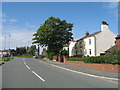
2
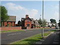
Barrow's Green Lane, Widnes
Barrow's Green Lane, Widnes with Cuerdley Cottage to the centre, marked as Wood End Farm on my old map.
Image: © Sue Adair
Taken: 8 Jun 2007
0.16 miles
3
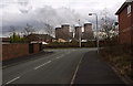
The end of Barneston Road, in the shadow of Fiddler's Ferry Power Station
Image: © Ian Greig
Taken: 9 Mar 2012
0.19 miles
5
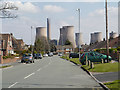
Chorley's Lane
The houses on Chorley's Lane, with the skyline dominated by the huge cooling towers of the Fiddler's Ferry Power Station.
Image: © David Dixon
Taken: 20 Apr 2013
0.21 miles