IMAGES TAKEN NEAR TO
Barnes Close, WIDNES, WA8 3LQ
Introduction
This page details the photographs taken nearby to Barnes Close, WA8 3LQ by members of the Geograph project.
The Geograph project started in 2005 with the aim of publishing, organising and preserving representative images for every square kilometre of Great Britain, Ireland and the Isle of Man.

There are currently over 7.5m images from over14,400 individuals and you can help contribute to the project by visiting https://www.geograph.org.uk
Image Map
Images are licensed for reuse under creativecommons.org/licenses/by-sa/2.0
Notes
- Clicking on the map will re-center to the selected point.
- The higher the marker number, the further away the image location is from the centre of the postcode.
Image Listing (6 Images Found)
Images are licensed for reuse under creativecommons.org/licenses/by-sa/2.0
Image
Details
Distance
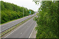
1
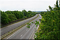
Watkinson Way
The A557 which now cuts a swath through Widnes on its way linking the M62 with the crossing of the Mersey.
Image: © Bill Boaden
Taken: 22 May 2017
0.12 miles
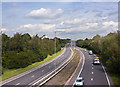
3
Watkinson Way
The A557 which now cuts a swath through Widnes on its way to the crossing of the Mersey.
Image: © Bill Boaden
Taken: 22 May 2017
0.21 miles
4
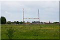
Former playing fields
These playing fields belonged to part of Wade Deacon High School. Part of the site is now being used for new housing development.
Image: © Bill Boaden
Taken: 22 May 2017
0.22 miles
5
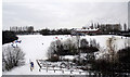
Widnes A Snowy Bongs
The Bongs area of Widnes and the old snow run used over generations by young and old alike
Image: © Alan James
Taken: 6 Jan 2010
0.22 miles
6
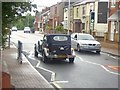
Halton View Road, Halton View
Looking along Halton View Road, (B5178). St. Ambrose Church is behind the photo view and just off the right edge of the photo is Bargain Booze then the Post Office.
The dark car caught my eye at the time.
Image: © Carl Farnell
Taken: 19 Aug 2006
0.23 miles