IMAGES TAKEN NEAR TO
Bishops Way, WIDNES, WA8 3LN
Introduction
This page details the photographs taken nearby to Bishops Way, WA8 3LN by members of the Geograph project.
The Geograph project started in 2005 with the aim of publishing, organising and preserving representative images for every square kilometre of Great Britain, Ireland and the Isle of Man.

There are currently over 7.5m images from over14,400 individuals and you can help contribute to the project by visiting https://www.geograph.org.uk
Image Map
Images are licensed for reuse under creativecommons.org/licenses/by-sa/2.0
Notes
- Clicking on the map will re-center to the selected point.
- The higher the marker number, the further away the image location is from the centre of the postcode.
Image Listing (10 Images Found)
Images are licensed for reuse under creativecommons.org/licenses/by-sa/2.0
Image
Details
Distance
1
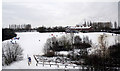
Widnes A Snowy Bongs
The Bongs area of Widnes and the old snow run used over generations by young and old alike
Image: © Alan James
Taken: 6 Jan 2010
0.05 miles
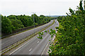
2
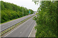
Watkinson Way
The A557 which now cuts a swath through Widnes on its way to the crossing of the Mersey.
Image: © Bill Boaden
Taken: 22 May 2017
0.15 miles
3
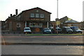
The Moorfield Arms
The Moorfield Arms, Crow Wood near Widnes.
Image: © andy
Taken: 26 Jun 2005
0.17 miles
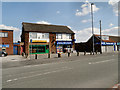
4
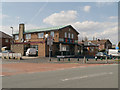
The Crow's Nest
Estate pub at the corner of Moorfield Road and Crow Wood Lane.
Image: © David Dixon
Taken: 20 Apr 2013
0.18 miles
5
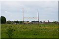
Former playing fields
These playing fields belonged to part of Wade Deacon High School. Part of the site is now being used for new housing development.
Image: © Bill Boaden
Taken: 22 May 2017
0.19 miles
6
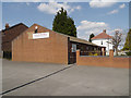
Kingdom Hall of Jehovah's Witnesses
At the junction of Moorfield Road and Dykin Road.
Image: © David Dixon
Taken: 20 Apr 2013
0.20 miles
8
Watkinson Way
The A557 which now cuts a swath through Widnes on its way linking the M62 with the crossing of the Mersey.
Image: © Bill Boaden
Taken: 22 May 2017
0.21 miles
9
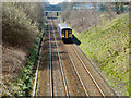
Train Approaching
Northern Rail Sprinter DMU 150274 passes the Rockwood Chemical Plant at Widnes. It is headed in the direction of Warrington, from Liverpool Lime Street, and is approaching the bridge at Moorfield Road, from where this photograph was taken..
Image: © David Dixon
Taken: 20 Apr 2013
0.22 miles
10
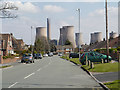
Chorley's Lane
The houses on Chorley's Lane, with the skyline dominated by the huge cooling towers of the Fiddler's Ferry Power Station.
Image: © David Dixon
Taken: 20 Apr 2013
0.24 miles