IMAGES TAKEN NEAR TO
Hampton Court Way, WIDNES, WA8 3EF
Introduction
This page details the photographs taken nearby to Hampton Court Way, WA8 3EF by members of the Geograph project.
The Geograph project started in 2005 with the aim of publishing, organising and preserving representative images for every square kilometre of Great Britain, Ireland and the Isle of Man.

There are currently over 7.5m images from over14,400 individuals and you can help contribute to the project by visiting https://www.geograph.org.uk
Image Map
Images are licensed for reuse under creativecommons.org/licenses/by-sa/2.0
Notes
- Clicking on the map will re-center to the selected point.
- The higher the marker number, the further away the image location is from the centre of the postcode.
Image Listing (15 Images Found)
Images are licensed for reuse under creativecommons.org/licenses/by-sa/2.0
Image
Details
Distance
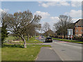
1
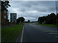
Derby Road approaching Mill Lane roundabout
Image: © Colin Pyle
Taken: 7 Aug 2010
0.01 miles
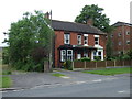
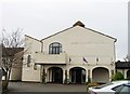
3
The Evergalades Park Hotel
Best Western on Derby Road.
Image: © JThomas
Taken: 5 Jun 2014
0.04 miles
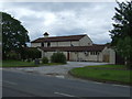
8
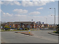
Derby Road Roundabout (A5080)
Looking over the Derby Road Roundabout, towards Moorfield Road. Cooling towers of Fiddlers Ferry Power Station are visible in the background.
Image: © David Dixon
Taken: 20 Apr 2013
0.08 miles
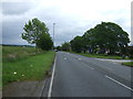
10
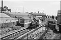
Farnworth and Bold Station ? 1964
On the former St Helens and Runcorn Gap Railway, one of the earlier railways in the area, opened in 1833. Eventually it became part of the London and North Western Railway.
The line never had heavy passenger levels and passenger services were withdrawn in 1951. The station itself continued to handle local goods until June 1964, a few weeks before this picture was taken, although the Spence alum chemical plant (left) and the Turner's Asbestos (Eternit) factory (right) continued to take rail traffic until c.1973 and 1981 respectively after which the line closed completely. It now forms the line of Watkinson Way, the Widnes eastern bypass https://www.geograph.org.uk/photo/3422502
The locomotive is 46424, one of the Ivatt class 2 2-6-0 locomotives built by the LMS shortly before nationalisation.
Image: © Alan Murray-Rust
Taken: 29 Jun 1964
0.14 miles