IMAGES TAKEN NEAR TO
Dalwood Close, RUNCORN, WA7 6JL
Introduction
This page details the photographs taken nearby to Dalwood Close, WA7 6JL by members of the Geograph project.
The Geograph project started in 2005 with the aim of publishing, organising and preserving representative images for every square kilometre of Great Britain, Ireland and the Isle of Man.

There are currently over 7.5m images from over14,400 individuals and you can help contribute to the project by visiting https://www.geograph.org.uk
Image Map
Images are licensed for reuse under creativecommons.org/licenses/by-sa/2.0
Notes
- Clicking on the map will re-center to the selected point.
- The higher the marker number, the further away the image location is from the centre of the postcode.
Image Listing (13 Images Found)
Images are licensed for reuse under creativecommons.org/licenses/by-sa/2.0
Image
Details
Distance
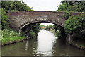
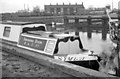
2

Bridgewater canal, between bridges 68 and 69
The houses are on Quay Place, but there was never a wharf here. On the Runcorn section of the Bridgewater canal. This was originally the main line of the canal, linking Manchester and Liverpool via the tidal Mersey at Runcorn.
Image: © Christine Johnstone
Taken: 30 May 2021
0.17 miles
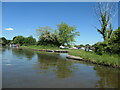
4
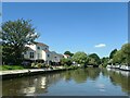
Marina village, Bridgewater canal
On the Runcorn section of the Bridgewater canal. This was originally the main line of the canal, linking Manchester and Liverpool via the tidal Mersey at Runcorn.
Image: © Christine Johnstone
Taken: 30 May 2021
0.18 miles
5
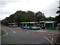
Buses at Murdishaw Centre
Murdishaw is a major stop on the Runcorn Busway, a dedicated bus only road that serves most of Runcorn new town. Except at bus stops, pedestrians are not permitted on the busway, hence the provision of the footbridge (left background) to allow access to the shops from the houses south of the busway. The two buses seen here are operating the busway circular service, which circumnavigates the main part of the busway at frequent intervals. Contrary to appearances, they are running in opposite directions: all buses stop on the same side of the busway here, regardless of direction of travel, with westbound buses using the turning circle to access the bus stop (see Image). Other services that use the busway go further afield; for example there are buses from here to Warrington, Widnes, and Liverpool, among others.
Image: © Richard Vince
Taken: 28 Jul 2012
0.21 miles
6
Norton Cottages
Looking across Norton Basin onto the rear elevation of Norton Cottages. At the time of the photo these were the only houses near the basin. Since then the area has experienced massive redevelopment as more recent photos here will show.
In the immediate foreground is the stern of 'Symbol' - originally a Shropshire Union Railway's & Canal Company horsedrawn 'fly' boat & then one of the few remaining examples. Sadly this historic craft has not survived, a well-meaning restoration plan failed as is described here: http://www.canaljunction.com/mainline/0112.htm
Image: © Martin Tester
Taken: Unknown
0.22 miles
7
Murdishaw Centre
A view of the small shopping centre at Murdishaw, seen from across the bus turning circle. In addition to functioning as a bus terminus, the turning circle exists to allow buses travelling west to turn east to stop outside the shopping centre, and then turn west again to resume their journeys. Note the fortifications defending the CCTV camera pole in the right foreground.
Image: © Richard Vince
Taken: 28 Jul 2012
0.22 miles
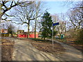
8
Cycleway sign on Falstone Drive
Burrow's bridge over the Bridgewater Canal seen in background
Image: © Raymond Knapman
Taken: 19 Mar 2015
0.23 miles
9
Entrance to Preston Brook marina
Discreet entrance for a fair-sized marina. On the north bank of the Runcorn section of the Bridgewater Canal.
Image: © Christine Johnstone
Taken: 30 May 2021
0.23 miles
10
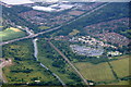
Preston Brook Marina, Runcorn from the air
Taken from a plane on the approach to Liverpool John Lennon Airport.
Image: © Mike Pennington
Taken: 5 Jul 2016
0.25 miles