IMAGES TAKEN NEAR TO
Westfield Road, RUNCORN, WA7 4DF
Introduction
This page details the photographs taken nearby to Westfield Road, WA7 4DF by members of the Geograph project.
The Geograph project started in 2005 with the aim of publishing, organising and preserving representative images for every square kilometre of Great Britain, Ireland and the Isle of Man.

There are currently over 7.5m images from over14,400 individuals and you can help contribute to the project by visiting https://www.geograph.org.uk
Image Map
Images are licensed for reuse under creativecommons.org/licenses/by-sa/2.0
Notes
- Clicking on the map will re-center to the selected point.
- The higher the marker number, the further away the image location is from the centre of the postcode.
Image Listing (7 Images Found)
Images are licensed for reuse under creativecommons.org/licenses/by-sa/2.0
Image
Details
Distance
1
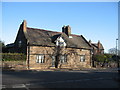
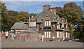
Brookfield Farm, Weston Road
Stone farmhouse dated 1691 on Weston Road, Higher Runcorn.
Image: © Sue Adair
Taken: 23 Nov 2007
0.16 miles
3
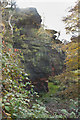
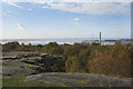
The cliff at Runcorn Hill
Originally a sandstone quarry
Image: © Ian Greig
Taken: 26 Oct 2012
0.20 miles