IMAGES TAKEN NEAR TO
Aston Lane, RUNCORN, WA7 3DF
Introduction
This page details the photographs taken nearby to Aston Lane, WA7 3DF by members of the Geograph project.
The Geograph project started in 2005 with the aim of publishing, organising and preserving representative images for every square kilometre of Great Britain, Ireland and the Isle of Man.

There are currently over 7.5m images from over14,400 individuals and you can help contribute to the project by visiting https://www.geograph.org.uk
Image Map
Images are licensed for reuse under creativecommons.org/licenses/by-sa/2.0
Notes
- Clicking on the map will re-center to the selected point.
- The higher the marker number, the further away the image location is from the centre of the postcode.
Image Listing (6 Images Found)
Images are licensed for reuse under creativecommons.org/licenses/by-sa/2.0
Image
Details
Distance
3
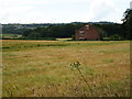
Derelict building near Parkside Farm
Blackamoor Wood behind and in the distance are the hills south of Frodsham
Image: © Maggie Cox
Taken: 29 Jul 2013
0.22 miles
4
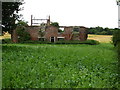
Derelict building near Parkside Farm
Old Moat Wood behind
Image: © Maggie Cox
Taken: 29 Jul 2013
0.22 miles
6
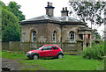
Lodge, Aston
Former Top Lodge to Aston Hall (demolished in 1938). Its design has been attributed to Samuel Wyatt, presumably because he worked on the big house in the 1790s. Grade II listed.
Image: © Stephen Richards
Taken: 17 Jun 2016
0.24 miles