IMAGES TAKEN NEAR TO
Dukes Wharf, RUNCORN, WA7 3AE
Introduction
This page details the photographs taken nearby to Dukes Wharf, WA7 3AE by members of the Geograph project.
The Geograph project started in 2005 with the aim of publishing, organising and preserving representative images for every square kilometre of Great Britain, Ireland and the Isle of Man.

There are currently over 7.5m images from over14,400 individuals and you can help contribute to the project by visiting https://www.geograph.org.uk
Image Map
Images are licensed for reuse under creativecommons.org/licenses/by-sa/2.0
Notes
- Clicking on the map will re-center to the selected point.
- The higher the marker number, the further away the image location is from the centre of the postcode.
Image Listing (64 Images Found)
Images are licensed for reuse under creativecommons.org/licenses/by-sa/2.0
Image
Details
Distance
1
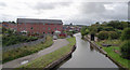
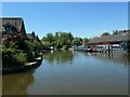
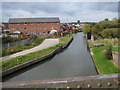
Bridgewater Canal (Norton Arm) near Preston Brook, Cheshire
This branch of the Bridgewater Canal goes to Runcorn, where it used to continue down ten wide locks to the River Mersey. The aqueduct this side of the apartment block crosses the cutting containing the railway line which links Manchester and Crewe. On the skyline is Norton Water Tower.
Image: © Roger D Kidd
Taken: 29 Aug 2011
0.03 miles
2
Bridgewater Canal (Norton Arm) near Preston Brook, Cheshire
This canal arm goes to Runcorn, where it used to continue down ten wide locks to the River Mersey.
Image: © Roger D Kidd
Taken: 29 Aug 2011
0.03 miles
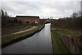
4
Bridgewater Canal (Norton Arm) near Preston Brook, Cheshire
This branch of the Bridgewater Canal goes to Runcorn, where it used to continue down ten wide locks to the River Mersey. The aqueduct in the foreground crosses the railway line which links Manchester and Crewe. On the skyline is Norton Water Tower.
Image: © Roger D Kidd
Taken: 29 Aug 2011
0.04 miles
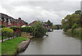
5
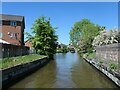
Norton Arm, Bridgewater canal
On the Runcorn section of the Bridgewater canal. The Runcorn section was originally the main line of the canal, linking Manchester and Liverpool via the tidal Mersey at Runcorn.
Image: © Christine Johnstone
Taken: 30 May 2021
0.05 miles
6
Aqueduct over Keckwick Brook
On the Runcorn section of the Bridgewater canal. This was originally the main line of the canal, linking Manchester and Liverpool via the tidal Mersey at Runcorn.
Image: © Christine Johnstone
Taken: 30 May 2021
0.05 miles
7
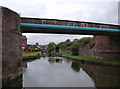
Footbridge over Bridgewater Canal
Bridgewater Canal - Runcorn Section at Preston Brook Junction
Image: © Mike Todd
Taken: 16 May 2011
0.05 miles
8
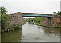
The Bridgewater Canal Junction, Preston Brook, Cheshire
This is the Norton arm of the canal from Runcorn approaching the main line. To the left is Manchester, and to the right is the link to the Trent and Mersey Canal via Preston Brook Tunnel. The near bridge carries the towpath across the branch, and the larger concrete bridge beyond carries the M56 motorway.
Image: © Roger D Kidd
Taken: 29 Aug 2011
0.06 miles
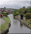
9
Bridgewater Canal
Looking northwest along the Bridgewater canal from the footbridge where the Trent and Mersey joins the Bridgewater
Image: © Peter Fleming
Taken: 9 Oct 2009
0.06 miles
10
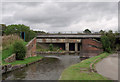
Bridgewater Canal (Norton Arm), near Preston Brook, Cheshire
This canal arm goes to Runcorn, where it used to continue down ten wide locks to the River Mersey. The bridge carries the towpath of the main line of the Bridgewater Canal, which continues north-eastwards towards Manchester.
Image: © Roger D Kidd
Taken: 30 Aug 2011
0.06 miles