IMAGES TAKEN NEAR TO
Calvers, RUNCORN, WA7 2EP
Introduction
This page details the photographs taken nearby to Calvers, WA7 2EP by members of the Geograph project.
The Geograph project started in 2005 with the aim of publishing, organising and preserving representative images for every square kilometre of Great Britain, Ireland and the Isle of Man.

There are currently over 7.5m images from over14,400 individuals and you can help contribute to the project by visiting https://www.geograph.org.uk
Image Map
Images are licensed for reuse under creativecommons.org/licenses/by-sa/2.0
Notes
- Clicking on the map will re-center to the selected point.
- The higher the marker number, the further away the image location is from the centre of the postcode.
Image Listing (21 Images Found)
Images are licensed for reuse under creativecommons.org/licenses/by-sa/2.0
Image
Details
Distance


3
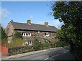
The Village Farmhouse, Halton
The ancient village of Halton clusters around the base of a rocky promontory overlooking the River Mersey upon which stand the remains of the castle. It has many old buildings, the Village Farmhouse dates from the early 17th century.
Image: © Sue Adair
Taken: 1 Apr 2008
0.17 miles
4

Halton House, Main Street, Halton
Halton House, Main Street, built in 1779.
Image: © Sue Adair
Taken: 1 Apr 2008
0.20 miles
5
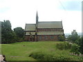
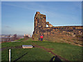
View from Runcorn Castle
Church of St Mary the Virgin stands just to the side of Runcorn Castle site, Halton Village.
Image: © russ
Taken: 10 Jul 2005
0.20 miles
6
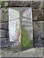
Old Milepost by the former A533, Main Street, Halton
Cast iron post by the UC road (was A533), in parish of Runcorn (Halton District), by No 63, Main Street, Halton, in pavement, back to garden wall, west side of road. Cast iron CCC1922, erected by the County Council in the 20th century.
Inscription reads:-
: RUNCORN 2 : : CHESHIRE / 1922 / COUNTY COUNCIL : : FRODSHAM 3¾ / PARTINGTON 8 / NORTHWICH 10 :
Maker:-
: W H SMITH & CO / MAKERS / WHITCHURCH :
Milestone Society National ID: CH_NTRC10
Image: © B Russell
Taken: 6 Feb 2012
0.21 miles
8
Halton Castle
Halton Castle - view towards the River Mersey with Fiddler's Ferry power station in the distance
Image: © Mike Harris
Taken: 14 Jan 2007
0.22 miles
9
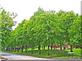
Halton Brook Avenue, Runcorn
The landscaped view created in 1972 upon exiting the now gone traffic-calming chicane to enter the former social housing estate, much of which is now in private ownership. The road layout was remodelled and junction priorities changed in 2012. The chicane served a practical purpose as deterrent to heavy goods vehicles which would struggle with the winding downhill passage further into the estate.
Image: © Pete Jinks
Taken: Unknown
0.22 miles
