IMAGES TAKEN NEAR TO
Hankey Street, RUNCORN, WA7 1EE
Introduction
This page details the photographs taken nearby to Hankey Street, WA7 1EE by members of the Geograph project.
The Geograph project started in 2005 with the aim of publishing, organising and preserving representative images for every square kilometre of Great Britain, Ireland and the Isle of Man.

There are currently over 7.5m images from over14,400 individuals and you can help contribute to the project by visiting https://www.geograph.org.uk
Image Map
Images are licensed for reuse under creativecommons.org/licenses/by-sa/2.0
Notes
- Clicking on the map will re-center to the selected point.
- The higher the marker number, the further away the image location is from the centre of the postcode.
Image Listing (261 Images Found)
Images are licensed for reuse under creativecommons.org/licenses/by-sa/2.0
Image
Details
Distance
1
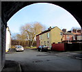
Rutland Street, Runcorn
Viewed from under a railway viaduct. Rutland Street leads to Hankey Street. http://www.geograph.org.uk/photo/5543729
Image: © Jaggery
Taken: 4 Feb 2017
0.01 miles
2
Hankey Street, Runcorn
Viewed from the corner of Rutland Street. http://www.geograph.org.uk/photo/5543723
Image: © Jaggery
Taken: 4 Feb 2017
0.01 miles
3
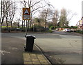
Warning sign - humps for 300 yards, Brindley Street, Runcorn
The black arrow on the sign facing Rutland Street points right along Brindley Street.
Image: © Jaggery
Taken: 4 Feb 2017
0.02 miles
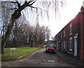
4
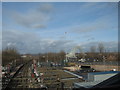
Railway Track and Bridge from Runcorn Station
Railway track at Runcorn Station and Queensway Bridge, taken from the footbridge over the lines at the station.
Image: © Sue Adair
Taken: 2 Feb 2008
0.03 miles
5
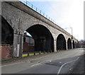
Runcorn Railway Viaduct
Some of the many viaduct arches viewed across a Brindley Street speed bump.
Image: © Jaggery
Taken: 4 Feb 2017
0.03 miles
6
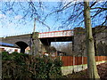
Metal bridge in a stone viaduct, Runcorn
Part of the railway viaduct north of Runcorn station.
Image: © Jaggery
Taken: 4 Feb 2017
0.03 miles
7
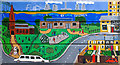
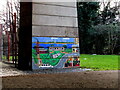
Urban art on road bridge
An image of Runcorn, painted by local schoolchildren, on one of the support pillars for the A553 - the power station at nearby Cuerdley Cross can be seen at the top of the painting (see Geograph image Image for comparison). This colourful image has sadly been vandalised by a local graffiti artist, whose attention appears to have been directed primarily at an adjacent image not shown here.
Image: © William Starkey
Taken: 15 Mar 2013
0.04 miles
9
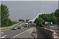
Queensway, Runcorn
Runcorn is a town that can seem overwhelmed by its road system. This is Queensway leading up to the Runcorn - Widnes Bridge over the River Mersey; on the right is Waterloo Bridge over the Bridgewater Canal.
Image: © Stephen McKay
Taken: 17 Jul 2007
0.05 miles
10
Mural below the A533, Runcorn
On a bridge support south of Egerton Street viewed in February 2017.
Image: © Jaggery
Taken: 4 Feb 2017
0.06 miles