IMAGES TAKEN NEAR TO
New Pale Road, FRODSHAM, WA6 9EZ
Introduction
This page details the photographs taken nearby to New Pale Road, WA6 9EZ by members of the Geograph project.
The Geograph project started in 2005 with the aim of publishing, organising and preserving representative images for every square kilometre of Great Britain, Ireland and the Isle of Man.

There are currently over 7.5m images from over14,400 individuals and you can help contribute to the project by visiting https://www.geograph.org.uk
Image Map
Images are licensed for reuse under creativecommons.org/licenses/by-sa/2.0
Notes
- Clicking on the map will re-center to the selected point.
- The higher the marker number, the further away the image location is from the centre of the postcode.
Image Listing (5 Images Found)
Images are licensed for reuse under creativecommons.org/licenses/by-sa/2.0
Image
Details
Distance
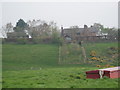
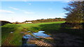
2
New Pale Road
New Pale Road heading south towards Manley Common.
Image: © Jeff Buck
Taken: 16 Sep 2015
0.09 miles
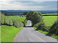
3
View from New Pale Road
The view north-east from New Pale Road near the Eddisbury Way.
Image: © Jeff Buck
Taken: 16 Sep 2015
0.11 miles
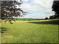
4
The Eddisbury Way
The Eddisbury Way heading north from New Pale Road near Manley.
Image: © Jeff Buck
Taken: 16 Sep 2015
0.14 miles
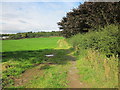
5
Eddisbury Way running N from New Pale Rd, Manley
Image: © Colin Park
Taken: 15 Dec 2020
0.15 miles