IMAGES TAKEN NEAR TO
Four Lane Ends, FRODSHAM, WA6 9EF
Introduction
This page details the photographs taken nearby to Four Lane Ends, WA6 9EF by members of the Geograph project.
The Geograph project started in 2005 with the aim of publishing, organising and preserving representative images for every square kilometre of Great Britain, Ireland and the Isle of Man.

There are currently over 7.5m images from over14,400 individuals and you can help contribute to the project by visiting https://www.geograph.org.uk
Image Map
Images are licensed for reuse under creativecommons.org/licenses/by-sa/2.0
Notes
- Clicking on the map will re-center to the selected point.
- The higher the marker number, the further away the image location is from the centre of the postcode.
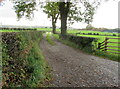
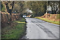
Image Listing (20 Images Found)
Images are licensed for reuse under creativecommons.org/licenses/by-sa/2.0
Image
Details
Distance
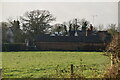
3
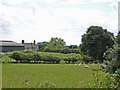
Rangeway Bank Farm, Manley
Rangeway Bank Farm, Manley from the Sandstone Trail (New Pale Road).
Image: © Mike Harris
Taken: 14 Jul 2007
0.03 miles
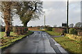
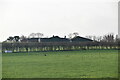
7
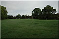
Mouldsworth Football Pitch
This is the football pitch in the small village of Mouldsworth
Image: © andy
Taken: 9 Oct 2005
0.18 miles