IMAGES TAKEN NEAR TO
Stanneybrook Close, FRODSHAM, WA6 8PZ
Introduction
This page details the photographs taken nearby to Stanneybrook Close, WA6 8PZ by members of the Geograph project.
The Geograph project started in 2005 with the aim of publishing, organising and preserving representative images for every square kilometre of Great Britain, Ireland and the Isle of Man.

There are currently over 7.5m images from over14,400 individuals and you can help contribute to the project by visiting https://www.geograph.org.uk
Image Map
Images are licensed for reuse under creativecommons.org/licenses/by-sa/2.0
Notes
- Clicking on the map will re-center to the selected point.
- The higher the marker number, the further away the image location is from the centre of the postcode.
Image Listing (17 Images Found)
Images are licensed for reuse under creativecommons.org/licenses/by-sa/2.0
Image
Details
Distance
1
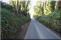
Hollow way at Norley Bank
Road leading north to Crowton.
Image: © Dave Dunford
Taken: 17 Feb 2013
0.02 miles
2
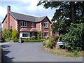
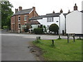
Norley - house at Crowton View
Small new housing development at the corner of Marsh Lane and Hollow Bank.
Image: © Mike Harris
Taken: 9 Aug 2006
0.05 miles
3
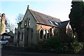
Methodist Church, Norley
Former Victorian church (built 1885) in Norley village.
Image: © Dave Dunford
Taken: 17 Feb 2013
0.14 miles
4
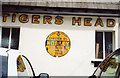
Old AA Sign on School Bank, Norley
Old AA Sign located on the wall of a building beside the Tiger's Head PH on the north side of School Bank, Norley, 5 miles southeast of Frodsham. Norley parish.
This is the Circular, village name on black band, no Motor Union symbol or name type, dating from 1923 and showing distances Chester 12½ Warrington 12½ London 179.
There were five series of AA signs, mostly dating from 1923 and made by Francis & Co / Franco in Deptford, London. The village name and distance to London or Dublin were normally displayed.
Milestone Society National ID: CH-NORL
Image: © Milestone Society
Taken: Unknown
0.19 miles
5
Bay Tree Cottage at Norley
On School Bank, by Pytchleys Hollow. The bay tree looks pretty old.
Image: © M J Richardson
Taken: 14 May 2011
0.19 miles
6
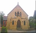
Methodist Church, Norley
School Bank, Norley. Built 1885.
Image: © Jo Lxix
Taken: 23 Jun 2006
0.20 miles
7
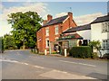
School Bank Norley, Village Stores
Norley is a village and civil parish in Cheshire, lying in rural farmland to the north of Delamere Forest and near the village of Cuddington. The civil parish population at the 2011 census was 1,169 (http://goo.gl/nMvg4E Office for National Statistics).
Image: © David Dixon
Taken: 7 Sep 2015
0.20 miles
8
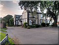
The Tigers Head at Norley
Large pub/restaurant at Norley, a village and civil parish in Cheshire which lies in rural farmland to the north of Delamere Forest and near the village of Cuddington. The civil parish population at the 2011 census was 1,169 (http://goo.gl/nMvg4E Office for National Statistics).
Image: © David Dixon
Taken: 7 Sep 2015
0.20 miles
9
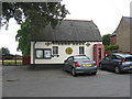
Building of the Tiger's Head pub at Norley
The main pub is out of shot at the left. The bowling green is behind. Note the red telephone box and 'historic' AA distance plaque - see Image
Image: © M J Richardson
Taken: 14 May 2011
0.21 miles
10
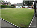
Crown green bowling green at Norley
At the Tiger's Head pub, which also has skittles available for customers' use. The green is unusual in that it is not square.
Image: © M J Richardson
Taken: 14 May 2011
0.22 miles