IMAGES TAKEN NEAR TO
Norley Road, FRODSHAM, WA6 8NE
Introduction
This page details the photographs taken nearby to Norley Road, WA6 8NE by members of the Geograph project.
The Geograph project started in 2005 with the aim of publishing, organising and preserving representative images for every square kilometre of Great Britain, Ireland and the Isle of Man.

There are currently over 7.5m images from over14,400 individuals and you can help contribute to the project by visiting https://www.geograph.org.uk
Image Map
Images are licensed for reuse under creativecommons.org/licenses/by-sa/2.0
Notes
- Clicking on the map will re-center to the selected point.
- The higher the marker number, the further away the image location is from the centre of the postcode.
Image Listing (5 Images Found)
Images are licensed for reuse under creativecommons.org/licenses/by-sa/2.0
Image
Details
Distance
1
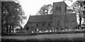
Norley Village Church
Parish church of St John the Evangelist, south side - where I was first married
Image: © Ben Brooksbank
Taken: 8 Oct 1961
0.06 miles
2
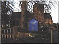
St John the Evangelist church, Norley
Looking north from the church car park to the church.
Image: © Paul McLaughlin
Taken: 3 Jan 2006
0.09 miles
4
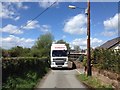
Lorry on Crabmill Lane
The place I was delivering to is in the background, clad in scaffolding. The lorry was a tight fit down this lane.
Image: © John Winder
Taken: 5 May 2015
0.14 miles
5
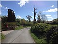
Crabmill Lane, Norley
Taken during a delivery of some floor joists on an articulated lorry. Fortunately, they were loaded on a small trailer as I don't think I'd have got down this lane with anything longer; it was a pretty tight squeeze as it was!
Image: © John Winder
Taken: 5 May 2015
0.16 miles