IMAGES TAKEN NEAR TO
Roddy Lane, FRODSHAM, WA6 8HQ
Introduction
This page details the photographs taken nearby to Roddy Lane, WA6 8HQ by members of the Geograph project.
The Geograph project started in 2005 with the aim of publishing, organising and preserving representative images for every square kilometre of Great Britain, Ireland and the Isle of Man.

There are currently over 7.5m images from over14,400 individuals and you can help contribute to the project by visiting https://www.geograph.org.uk
Image Map
Images are licensed for reuse under creativecommons.org/licenses/by-sa/2.0
Notes
- Clicking on the map will re-center to the selected point.
- The higher the marker number, the further away the image location is from the centre of the postcode.
Image Listing (5 Images Found)
Images are licensed for reuse under creativecommons.org/licenses/by-sa/2.0
Image
Details
Distance
1

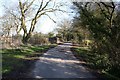
Roddy Lane near Kingsley
Heading east along Roddy Lane away from Kingsley.
Image: © Jeff Buck
Taken: 29 May 2023
0.12 miles
4
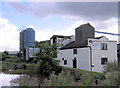
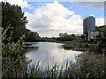
Kingsley Mill, Kingsley, Cheshire
A working mill producing animal feeds. No longer water powered although the mill pond remains and can be seen on the left.
Image: © Alan Godfree
Taken: 30 Jul 2006
0.24 miles
5
Beech Lane
Quiet back road between Norley and Crowton.
Image: © Dave Dunford
Taken: 17 Feb 2013
0.25 miles