IMAGES TAKEN NEAR TO
Bradley Lane, FRODSHAM, WA6 7EX
Introduction
This page details the photographs taken nearby to Bradley Lane, WA6 7EX by members of the Geograph project.
The Geograph project started in 2005 with the aim of publishing, organising and preserving representative images for every square kilometre of Great Britain, Ireland and the Isle of Man.

There are currently over 7.5m images from over14,400 individuals and you can help contribute to the project by visiting https://www.geograph.org.uk
Image Map
Images are licensed for reuse under creativecommons.org/licenses/by-sa/2.0
Notes
- Clicking on the map will re-center to the selected point.
- The higher the marker number, the further away the image location is from the centre of the postcode.
Image Listing (8 Images Found)
Images are licensed for reuse under creativecommons.org/licenses/by-sa/2.0
Image
Details
Distance
1
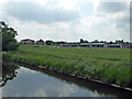
Catton Hall from the River Weaver
Quad World is situated here and there also appears to be equestrian facilities.
Image: © Chris Allen
Taken: 10 Jun 2018
0.06 miles
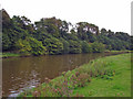
2
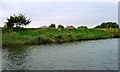
River Weaver flood bank, at Catton Hall
The west bank of the river.
Image: © Christine Johnstone
Taken: 13 Sep 2016
0.08 miles
3
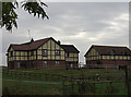
New housing near Catton Hall
By the banks of the Weaver Navigation.
Image: © michael ely
Taken: 18 Oct 2009
0.10 miles
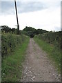
4
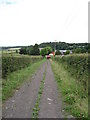
View of Footpath down to Catton Hall
The footpath is on a well-formed track, which continues, except for brief woodland section, all the way to Kingsley, and could form an old road?
Image: © David Quinn
Taken: 6 Jul 2009
0.13 miles
5
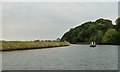
Narrowboat heading upstream on the River Weaver
By Old Moat Wood.
Image: © Christine Johnstone
Taken: 13 Sep 2016
0.14 miles
6
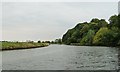
The River Weaver at Old Moat Wood
Looking downstream [locally north-west].
Image: © Christine Johnstone
Taken: 13 Sep 2016
0.14 miles
7
Kingsley - River Weaver near Catton Hall
Kingsley. View up the River Weaver from near Catton Hall. Old Moat Wood across the river.
Image: © Mike Harris
Taken: 17 Sep 2006
0.15 miles
8
View of Footpath near Catton Hall
The footpath is on a well-formed track, which continues, except for brief woodland section, all the way to Kingsley, and could form an old road? Warburton's Wood is in the background.
Image: © David Quinn
Taken: 6 Jul 2009
0.25 miles