IMAGES TAKEN NEAR TO
Tarvin Road, FRODSHAM, WA6 6XH
Introduction
This page details the photographs taken nearby to Tarvin Road, WA6 6XH by members of the Geograph project.
The Geograph project started in 2005 with the aim of publishing, organising and preserving representative images for every square kilometre of Great Britain, Ireland and the Isle of Man.

There are currently over 7.5m images from over14,400 individuals and you can help contribute to the project by visiting https://www.geograph.org.uk
Image Map
Images are licensed for reuse under creativecommons.org/licenses/by-sa/2.0
Notes
- Clicking on the map will re-center to the selected point.
- The higher the marker number, the further away the image location is from the centre of the postcode.
Image Listing (4 Images Found)
Images are licensed for reuse under creativecommons.org/licenses/by-sa/2.0
Image
Details
Distance
1
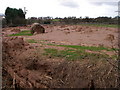
Landslide - in Cheshire?!
The toe of a landslide which took place a week or two back involving thousands of tonnes of glacial sand and clay on sloping agricultural land at Alvanley. A surprise to all concerned, not least the tractor driver who surfed it for 1/4 mile and emerged unscathed!
Image: © Alan Bowring
Taken: 24 Mar 2008
0.13 miles
2
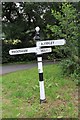
Old Direction Sign - Signpost by the B5393, Tarvin Road
Pawn finial - 3 arms; Cheshire CCC octagonal by the UC road, in parish of Alvanley (Vale Royal District), junction with The Ridgeway.
To be surveyed
Milestone Society National ID: CH_SJ5075
Image: © Milestone Society
Taken: Unknown
0.13 miles
4
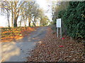
Entrance to Foxhill House and Woodlands
Looking northward.
Image: © Peter Wood
Taken: 17 Nov 2018
0.20 miles