IMAGES TAKEN NEAR TO
Kingswood, FRODSHAM, WA6 6JJ
Introduction
This page details the photographs taken nearby to WA6 6JJ by members of the Geograph project.
The Geograph project started in 2005 with the aim of publishing, organising and preserving representative images for every square kilometre of Great Britain, Ireland and the Isle of Man.

There are currently over 7.5m images from over14,400 individuals and you can help contribute to the project by visiting https://www.geograph.org.uk
Image Map
Images are licensed for reuse under creativecommons.org/licenses/by-sa/2.0
Notes
- Clicking on the map will re-center to the selected point.
- The higher the marker number, the further away the image location is from the centre of the postcode.
Image Listing (8 Images Found)
Images are licensed for reuse under creativecommons.org/licenses/by-sa/2.0
Image
Details
Distance
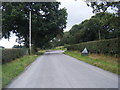
1
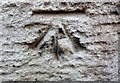
Cut Mark Hollins Farm Waterloo Rd Mouldsworth
Image: © Monica Stagg
Taken: 31 Oct 2015
0.15 miles
2
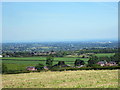
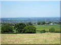
The view from Waterloo
View across north Cheshire from Waterloo.
Image: © Jeff Buck
Taken: 10 Jun 2015
0.15 miles
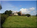
3
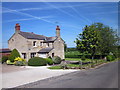
Hollins Farm at Waterloo
Hollins Farm on Waterloo Lane in the small hamlet of Waterloo.
Image: © Jeff Buck
Taken: 10 Jun 2015
0.15 miles
5
The view from Waterloo
The view across north Cheshire from Waterloo.
Image: © Jeff Buck
Taken: 10 Jun 2015
0.16 miles
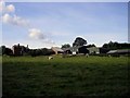
8
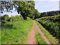
Footpath to Delamere Forest
Path leading to the northern side of Delamere Forest at Waterloo.
Image: © Jeff Buck
Taken: 10 Jun 2015
0.23 miles