IMAGES TAKEN NEAR TO
Rake Lane, FRODSHAM, WA6 0LR
Introduction
This page details the photographs taken nearby to Rake Lane, WA6 0LR by members of the Geograph project.
The Geograph project started in 2005 with the aim of publishing, organising and preserving representative images for every square kilometre of Great Britain, Ireland and the Isle of Man.

There are currently over 7.5m images from over14,400 individuals and you can help contribute to the project by visiting https://www.geograph.org.uk
Image Map
Images are licensed for reuse under creativecommons.org/licenses/by-sa/2.0
Notes
- Clicking on the map will re-center to the selected point.
- The higher the marker number, the further away the image location is from the centre of the postcode.
Image Listing (10 Images Found)
Images are licensed for reuse under creativecommons.org/licenses/by-sa/2.0
Image
Details
Distance

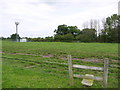
4
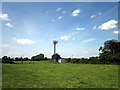
Cell site near Hob Lane
A radio mast for mobile phones next to Hob Lane.
Image: © Jeff Buck
Taken: 14 Jun 2011
0.19 miles


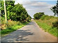
9
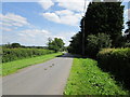
Rake Lane
The Radio/phone mast on the left doesn't seem to appear on the os map and the closed gate in the distance made any further progress along Rake Lane impossible.
Image: © Jeff Buck
Taken: 14 Jun 2011
0.22 miles