IMAGES TAKEN NEAR TO
Tan House Lane, WARRINGTON, WA5 4BY
Introduction
This page details the photographs taken nearby to Tan House Lane, WA5 4BY by members of the Geograph project.
The Geograph project started in 2005 with the aim of publishing, organising and preserving representative images for every square kilometre of Great Britain, Ireland and the Isle of Man.

There are currently over 7.5m images from over14,400 individuals and you can help contribute to the project by visiting https://www.geograph.org.uk
Image Map
Images are licensed for reuse under creativecommons.org/licenses/by-sa/2.0
Notes
- Clicking on the map will re-center to the selected point.
- The higher the marker number, the further away the image location is from the centre of the postcode.
Image Listing (9 Images Found)
Images are licensed for reuse under creativecommons.org/licenses/by-sa/2.0
Image
Details
Distance
2
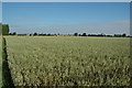
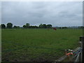
Farm land, Primrose Hill, Burtonwood
Primrose Hill Farm is somewhere to the left of this picture and I'm guessing here but I imagine this is their field of what I believe to be barley (certainly isn't wheat anyways).
Image: © andy
Taken: 17 Jul 2005
0.12 miles
3
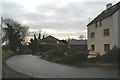
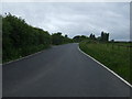
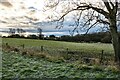
Looking towards Winwick from Tan House Lane
Image: © David Long
Taken: 2 Jan 2009
0.12 miles
5
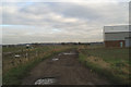
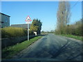
Farmers Lane
Heading west towards Burtonwood.
Image: © JThomas
Taken: 5 Jun 2014
0.13 miles
9
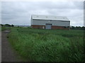
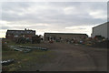
Primrose Hill Farm
Fields near Primrose Hill Farm.
Image: © Peter McDermott
Taken: 3 Jan 2021
0.25 miles