IMAGES TAKEN NEAR TO
Shoreham Drive, WARRINGTON, WA5 2HY
Introduction
This page details the photographs taken nearby to Shoreham Drive, WA5 2HY by members of the Geograph project.
The Geograph project started in 2005 with the aim of publishing, organising and preserving representative images for every square kilometre of Great Britain, Ireland and the Isle of Man.

There are currently over 7.5m images from over14,400 individuals and you can help contribute to the project by visiting https://www.geograph.org.uk
Image Map
Images are licensed for reuse under creativecommons.org/licenses/by-sa/2.0
Notes
- Clicking on the map will re-center to the selected point.
- The higher the marker number, the further away the image location is from the centre of the postcode.
Image Listing (11 Images Found)
Images are licensed for reuse under creativecommons.org/licenses/by-sa/2.0
Image
Details
Distance
1
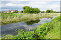
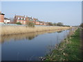
The St Helens Canal
On the other side are housing estates spreading out from Penketh.
Image: © Bill Boaden
Taken: 22 May 2017
0.14 miles
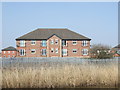
2
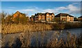
St Helens Canal
Housing alongside the disused St Helens Canal.
Image: © Peter McDermott
Taken: 3 Jan 2021
0.14 miles
3
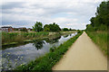
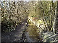
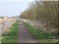
The Transpennine Trail by the St Helens Canal
A long straight stretch with not much variety.
Image: © Bill Boaden
Taken: 22 May 2017
0.16 miles
5
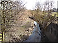
Whittle Brook
Looking upstream. Whittle Brook marks the boundary between Penketh and Great Sankey, Warrington. It is a tributary of the River Mersey which it joins just south of this point. Photograph taken from the Penketh Road/A562 bridge which crosses the brook here.
Image: © Keith Williamson
Taken: 10 Mar 2010
0.21 miles
6
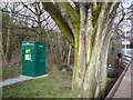
Flow measurement station
Flow measurement station located on the eastern bank of Whittle Brook at Penketh, Warrington.
Image: © Keith Williamson
Taken: 10 Mar 2010
0.21 miles
7
Whittle Brook
Looking downstream from the Penketh Road/A562 bridge which crosses the brook here. The stream joins the River Mersey about 500 metres from this point.
Image: © Keith Williamson
Taken: 10 Mar 2010
0.21 miles
10
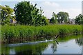
Cormorant ascending, Sankey Canal
This cormorant took off and landed, took off and landed, every time I caught up with him while cycling to work along the towpath. In the end I took his picture as it was obviously what he wanted.
Image: © Matt Harrop
Taken: 10 Jun 2015
0.21 miles