IMAGES TAKEN NEAR TO
Baxter Street, WARRINGTON, WA5 1AN
Introduction
This page details the photographs taken nearby to Baxter Street, WA5 1AN by members of the Geograph project.
The Geograph project started in 2005 with the aim of publishing, organising and preserving representative images for every square kilometre of Great Britain, Ireland and the Isle of Man.

There are currently over 7.5m images from over14,400 individuals and you can help contribute to the project by visiting https://www.geograph.org.uk
Image Map
Images are licensed for reuse under creativecommons.org/licenses/by-sa/2.0
Notes
- Clicking on the map will re-center to the selected point.
- The higher the marker number, the further away the image location is from the centre of the postcode.
Image Listing (47 Images Found)
Images are licensed for reuse under creativecommons.org/licenses/by-sa/2.0
Image
Details
Distance
1
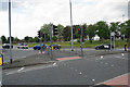
Sankey Roundabout
A large roundabout on the A57 on the western side of Warrington town centre. It is large enough to make it impossible to capture all of it in one image.
Image: © Bill Boaden
Taken: 22 May 2017
0.02 miles
2
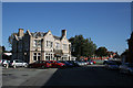
Bowling Green Inn
This pub now stands with its back to the main road which passes behind, but this was originally the main road to Liverpool.
Image: © Alan Murray-Rust
Taken: 6 Oct 2008
0.06 miles
3
Littons Mill Crossing
Level crossing on the former LNWR railway from Ditton Junction to Timperley (for Stockport). This section is still used to bring coal to Fiddler's Ferry power station, but the line is dismantled beyond Warrington.
Image: © Alan Murray-Rust
Taken: 6 Oct 2008
0.08 miles
4
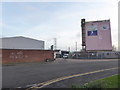
Quay Fold and the Warrington Eye
Quay Fold is the road opposite with the parked vans in it. The Warrington Eye is a mural by local artist Anthony Turk on a building that was a former grain store on Bank Quay.
Image: © Chris Allen
Taken: 29 Dec 2018
0.09 miles
5
A former pub on Old Liverpool Road
As with many former pubs, this is now a children's nursery.
Image: © Bill Boaden
Taken: 22 May 2017
0.09 miles
6
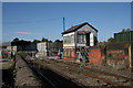
Litton's Mill Crossing
A fine London and North Western Railway signal box still adorns the crossing, but the gates are now manually operated. The mill referred to may or may not be the same as Faircloughs Mill which supports the Eye Image
Image: © Alan Murray-Rust
Taken: 6 Oct 2008
0.09 miles
7
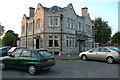
The Bowling Green, Warrington
This is the Bowling Green pub, so called because before all the new roads that were built around Warrington town centre, it used to have a bowling green at the back of it. It made way for a wider A5061...
Image: © andy
Taken: 26 Jun 2005
0.10 miles
9
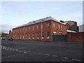
PQ Corporation, Warrington
Seen from near Lidl, this is part of the large chemical works owned by PQ Corporation that was formerly Unilever and was initially Joseph Crosfield. The works makes ingredients for detergents and toothpastes, particularly silicas. Amazingly, part of the site is traversed by the Mersey Way but photography is prohibited in the site. The site also contains a derelict transporter bridge dating to 1916 that is a Scheduled Ancient Monument and Grade II Listed.
The more recent ownership history from a fellow contributor is: - The site had been part of Unilever but was sold to ICI in 1999, who then sold it to INEOS 2 years later as part of the slow break-up of ICI. INEOS was merged into PQ Corporation in 2008.
Image: © Chris Allen
Taken: 29 Dec 2018
0.10 miles
10
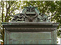
Joseph Crosfield & Sons War Memorial - inscription and detail
The detail at the top of Image
The inscription reads:
JOSEPH CROSSFIELD & SONS LIMITED
IN MEMORY OF THE MEN OF THIS FIRM
WHO DIED FOR THEIR COUNTRY IN
THE GREAT WARS*
*The “s” on the end has clearly been added later, to include the Second World War. The names of the dead are included on two panels under the inscription.
Image] World War I
Image] World War II
Image: © David Dixon
Taken: 27 Jul 2012
0.11 miles