IMAGES TAKEN NEAR TO
Longshaw Street, WARRINGTON, WA5 0DG
Introduction
This page details the photographs taken nearby to Longshaw Street, WA5 0DG by members of the Geograph project.
The Geograph project started in 2005 with the aim of publishing, organising and preserving representative images for every square kilometre of Great Britain, Ireland and the Isle of Man.

There are currently over 7.5m images from over14,400 individuals and you can help contribute to the project by visiting https://www.geograph.org.uk
Image Map
Images are licensed for reuse under creativecommons.org/licenses/by-sa/2.0
Notes
- Clicking on the map will re-center to the selected point.
- The higher the marker number, the further away the image location is from the centre of the postcode.
Image Listing (8 Images Found)
Images are licensed for reuse under creativecommons.org/licenses/by-sa/2.0
Image
Details
Distance
3
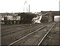
A 9F, 92156, with empty coal wagons, at Warrington (Dallam) locomomotive shed
Shortly before the demise of B.R. steam in the area.
Image: © Roger Cornfoot
Taken: Unknown
0.22 miles
6

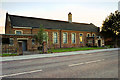
St Mark, Dallam
Church built 1954, consecrated 1957
Image: © S Parish
Taken: 14 Jan 2004
0.23 miles
7
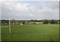
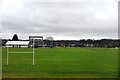
Dallam playing fields off Longshaw Street
Image: © John Firth
Taken: 10 May 2014
0.23 miles