IMAGES TAKEN NEAR TO
Walton Lea Road, WARRINGTON, WA4 6SJ
Introduction
This page details the photographs taken nearby to Walton Lea Road, WA4 6SJ by members of the Geograph project.
The Geograph project started in 2005 with the aim of publishing, organising and preserving representative images for every square kilometre of Great Britain, Ireland and the Isle of Man.

There are currently over 7.5m images from over14,400 individuals and you can help contribute to the project by visiting https://www.geograph.org.uk
Image Map
Images are licensed for reuse under creativecommons.org/licenses/by-sa/2.0
Notes
- Clicking on the map will re-center to the selected point.
- The higher the marker number, the further away the image location is from the centre of the postcode.
Image Listing (21 Images Found)
Images are licensed for reuse under creativecommons.org/licenses/by-sa/2.0
Image
Details
Distance
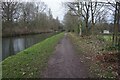
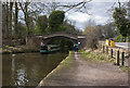
5
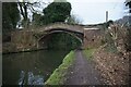
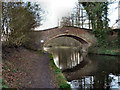
Entrance to Walton Hall Park - bridge over the Bridgewater Canal
For years this access was shared between infrequent service vehicles and pedestrians... it has now been duplicated by a pedestrian bridge.
Image: © David Long
Taken: 7 Jan 2009
0.15 miles
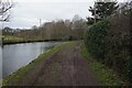
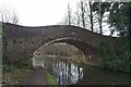
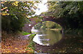
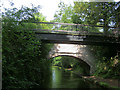
7
The Cheshire Ring
The Cheshire Ring is a 97 mile navigable ring of canals made up of all or part of six canals
Image: © Ian Greig
Taken: 5 Apr 2013
0.15 miles