IMAGES TAKEN NEAR TO
Hillcliffe Road, WARRINGTON, WA4 6NZ
Introduction
This page details the photographs taken nearby to Hillcliffe Road, WA4 6NZ by members of the Geograph project.
The Geograph project started in 2005 with the aim of publishing, organising and preserving representative images for every square kilometre of Great Britain, Ireland and the Isle of Man.

There are currently over 7.5m images from over14,400 individuals and you can help contribute to the project by visiting https://www.geograph.org.uk
Image Map
Images are licensed for reuse under creativecommons.org/licenses/by-sa/2.0
Notes
- Clicking on the map will re-center to the selected point.
- The higher the marker number, the further away the image location is from the centre of the postcode.
Image Listing (22 Images Found)
Images are licensed for reuse under creativecommons.org/licenses/by-sa/2.0
Image
Details
Distance
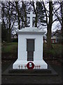
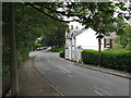
6
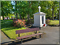
Lower Walton War Memorial and Memorial Garden
Image: © David Dixon
Taken: 25 May 2012
0.22 miles
8
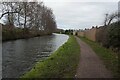
Fishing on the Bridgewater Canal
Looking west from the Red Lane Bridge, and backing on to the gardens of Westbourne Road.
Image: © M J Richardson
Taken: 15 May 2011
0.22 miles
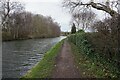
9
House on Red Lane
At the junction with Whitefield Road, just north of the Red Lane Bridge over the Bridgewater Canal
Image: © M J Richardson
Taken: 15 May 2011
0.22 miles
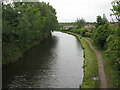
10
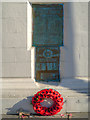
Lower Walton War Memorial
The dedication panels on Image
Image: © David Dixon
Taken: 25 May 2012
0.22 miles