IMAGES TAKEN NEAR TO
Walton Road, WARRINGTON, WA4 6NW
Introduction
This page details the photographs taken nearby to Walton Road, WA4 6NW by members of the Geograph project.
The Geograph project started in 2005 with the aim of publishing, organising and preserving representative images for every square kilometre of Great Britain, Ireland and the Isle of Man.

There are currently over 7.5m images from over14,400 individuals and you can help contribute to the project by visiting https://www.geograph.org.uk
Image Map
Images are licensed for reuse under creativecommons.org/licenses/by-sa/2.0
Notes
- Clicking on the map will re-center to the selected point.
- The higher the marker number, the further away the image location is from the centre of the postcode.
Image Listing (77 Images Found)
Images are licensed for reuse under creativecommons.org/licenses/by-sa/2.0
Image
Details
Distance
2
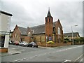
Stockton Heath Methodist Church
On Walton Road: http://shmc.org.uk/
Image: © Mike Faherty
Taken: 4 Aug 2015
0.02 miles
4

Stockton Heath Christian Fellowship
On Walton Road.
Image: © Mike Faherty
Taken: 4 Aug 2015
0.04 miles
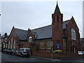
6

St Thomas' Church, Stockton Heath
Founded 1838 as the parish church for Acton Grange, Appleton (part), Walton Inferior and Walton Superior.
Image: © Anna Head
Taken: 30 Jun 2007
0.07 miles

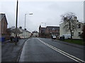
8
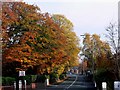
Autumn colours on Walton Road, Stockton Heath
Image: © Anna Head
Taken: 4 Nov 2007
0.10 miles

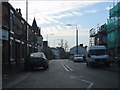
10
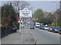
Stockton Heath
Looking North from London Bridge as the A49 enters Stockton Heath and then continues on into Warrington Town Centre
Image: © Ade Warburton
Taken: 15 Apr 2007
0.11 miles