IMAGES TAKEN NEAR TO
Whitefield Road, WARRINGTON, WA4 6ND
Introduction
This page details the photographs taken nearby to Whitefield Road, WA4 6ND by members of the Geograph project.
The Geograph project started in 2005 with the aim of publishing, organising and preserving representative images for every square kilometre of Great Britain, Ireland and the Isle of Man.

There are currently over 7.5m images from over14,400 individuals and you can help contribute to the project by visiting https://www.geograph.org.uk
Image Map
Images are licensed for reuse under creativecommons.org/licenses/by-sa/2.0
Notes
- Clicking on the map will re-center to the selected point.
- The higher the marker number, the further away the image location is from the centre of the postcode.
Image Listing (15 Images Found)
Images are licensed for reuse under creativecommons.org/licenses/by-sa/2.0
Image
Details
Distance
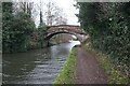
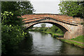
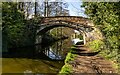
3
Fishing on the Bridgewater Canal
Looking west from the Red Lane Bridge, and backing on to the gardens of Westbourne Road.
Image: © M J Richardson
Taken: 15 May 2011
0.16 miles
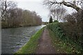
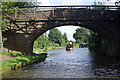
5
Bridgewater Canal: Red Lane Bridge 14
Image: © Dr Neil Clifton
Taken: 29 Mar 2015
0.19 miles
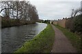
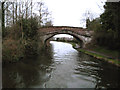
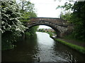
6
Red Lane Bridge, Bridgewater Canal
Although apparently rural, this stretch of the Bridgewater Canal runs through Warrington's southern suburbs.
Image: © Stephen McKay
Taken: 29 Aug 2010
0.19 miles
7
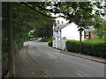
House on Red Lane
At the junction with Whitefield Road, just north of the Red Lane Bridge over the Bridgewater Canal
Image: © M J Richardson
Taken: 15 May 2011
0.20 miles
8
Bridgewater Canal
Red Lane crossing the Bridgewater Canal.
Image: © Peter McDermott
Taken: 2 Apr 2021
0.20 miles
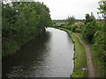
9
Red Lane Bridge, Bridgewater Canal, Stockton Heath
Number 14 in the canal guide, but the bridges on the Bridgewater Canal do not usually carry numbers and sometimes even the names are missing. Unusually, a civil parish boundary runs down the centre of the canal.
Image: © Christine Johnstone
Taken: 22 May 2021
0.20 miles