IMAGES TAKEN NEAR TO
Roman Road, WARRINGTON, WA4 6DX
Introduction
This page details the photographs taken nearby to Roman Road, WA4 6DX by members of the Geograph project.
The Geograph project started in 2005 with the aim of publishing, organising and preserving representative images for every square kilometre of Great Britain, Ireland and the Isle of Man.

There are currently over 7.5m images from over14,400 individuals and you can help contribute to the project by visiting https://www.geograph.org.uk
Image Map
Images are licensed for reuse under creativecommons.org/licenses/by-sa/2.0
Notes
- Clicking on the map will re-center to the selected point.
- The higher the marker number, the further away the image location is from the centre of the postcode.
Image Listing (72 Images Found)
Images are licensed for reuse under creativecommons.org/licenses/by-sa/2.0
Image
Details
Distance
1
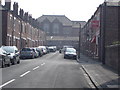
Roman Road, Stockton Heath
Looking up Roman Road from Ellesmere Road toward the rear of the school (centre of photo). This road terminates at the rear of the (soon to be demolished) school. There is a small corner shop (The Roman) to the right, just before the lamp post.
Image: © Ade Warburton
Taken: 15 Apr 2007
0.02 miles
2
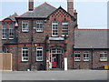
Stockton Heath Primary School
Taken from the entrance on Brackley Street prior to the school's pending demolition.
Image: © Ade Warburton
Taken: 15 Apr 2007
0.04 miles
3
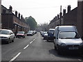
Brackley Street, Stockton Heath
View up Brackley Street from Ellesmere Road. The Horse Chestnut trees at the end of the street (top left) are at the entrance to the school which is destined to be demolished this summer (2007)
Image: © Ade Warburton
Taken: 15 Apr 2007
0.06 miles
4
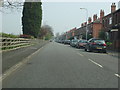
Ellesmere Road, Stockton Heath
View east along Ellesmere Road, Manchester Ship Canal down to the immediate left on the other side of the fence. This photo is aimed toward the swing bridge where the A49 crosses the canal
Image: © Ade Warburton
Taken: 15 Apr 2007
0.08 miles
5
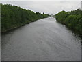
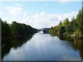
Looking west along the Manchester Ship Canal from Wilderspool
From the London Road Bridge [A49] to the Chester Road Bridge [A5060] and, beyond that, the main West Coast Main Line railway bridge.
Image: © M J Richardson
Taken: 15 May 2011
0.09 miles
7
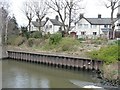
Houses off Greenall's Avenue
On the north bank of the Manchester Ship Canal.
Image: © Christine Johnstone
Taken: 13 Apr 2013
0.12 miles
9
Warrington, swing bridge
Northwich Road Swing Bridge, carrying A49 over Manchester Ship Canal, opening to let shipping though.
Image: © Mike Faherty
Taken: 18 Sep 2011
0.13 miles
10
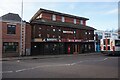
Bavette Restaurant, London Road, Stockton Heath
Image: © Ian S
Taken: 1 Mar 2022
0.14 miles