IMAGES TAKEN NEAR TO
Beamish Close, WARRINGTON, WA4 5RJ
Introduction
This page details the photographs taken nearby to Beamish Close, WA4 5RJ by members of the Geograph project.
The Geograph project started in 2005 with the aim of publishing, organising and preserving representative images for every square kilometre of Great Britain, Ireland and the Isle of Man.

There are currently over 7.5m images from over14,400 individuals and you can help contribute to the project by visiting https://www.geograph.org.uk
Image Map
Images are licensed for reuse under creativecommons.org/licenses/by-sa/2.0
Notes
- Clicking on the map will re-center to the selected point.
- The higher the marker number, the further away the image location is from the centre of the postcode.
Image Listing (25 Images Found)
Images are licensed for reuse under creativecommons.org/licenses/by-sa/2.0
Image
Details
Distance
![London Road [A49], Stretton](https://s1.geograph.org.uk/geophotos/02/41/49/2414925_1553dbc6_120x120.jpg)
2
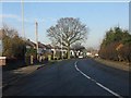
London Road, Stretton
Housing along the A49 north of Stretton crossroads is largely classic British "semis" whose spacious gardens sit in stark contrast to the "new town era" housing of Pewterspear a few hundred yards to the east.
Image: © Peter Whatley
Taken: 17 Jan 2012
0.08 miles
3
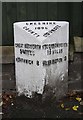
Old Milepost by the A49 in Stretton
Cast iron post by the A49, in parish of Stretton (Warrington District), Pewterspear, half mile North of Stretton Cross Roads, in pavement, back to low brick wall. Cast iron CCC1896, erected by the County Council in the 19th century.
Inscription reads:-
: GREAT BUDWORTH / 5 MILES / NORTHWICH 8 : : CHESHIRE / 1896 / COUNTY COUNCIL : : STOCKTON HEATH / 1¾ MILES / WARRINGTON 3 :
Maker:-
: W H SMITH & CO / MAKERS / WHITCHURCH:
Grade II listed.
List Entry Number: 1392450 https://historicengland.org.uk/listing/the-list/list-entry/1392450
Milestone Society National ID: CH_WANW03
Image: © Gillian Oakes
Taken: 1 Jan 2003
0.08 miles
4
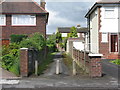
Alley between the houses
Connecting Acton Avenue with the main London Road [A49].
Image: © M J Richardson
Taken: 14 May 2011
0.09 miles
7
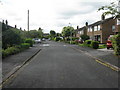
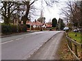
Acton Avenue, Stretton
A cul-de-sac from London Road [A49], and parallel to it.
Image: © M J Richardson
Taken: 14 May 2011
0.11 miles
8
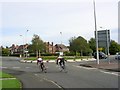
Owens Corner
Cyclists approaching Owens Corner roundabout at Appleton. The major road here (running top to bottom) is the A49, London Road. The section beyond the roundabout follows the course of the old Roman road leaving Warrington for the south. The Roman road continues south from the roundabout along what is now a public footpath that leaves the picture roughly where the car is on the rhs. SJ61788340.
Image: © Keith Williamson
Taken: 9 Oct 2005
0.14 miles
10
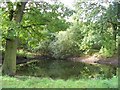
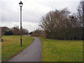
Pond in Woods
A pond in woods close to Pewterspear, Appleton near Warrington. This area has been extensively developed for Warrington New Town but many areas of open land and woodland have been retained. The mature trees here are mostly oak.
Image: © Keith Williamson
Taken: 9 Oct 2005
0.15 miles