IMAGES TAKEN NEAR TO
St. Georges Close, WARRINGTON, WA4 5RB
Introduction
This page details the photographs taken nearby to St. Georges Close, WA4 5RB by members of the Geograph project.
The Geograph project started in 2005 with the aim of publishing, organising and preserving representative images for every square kilometre of Great Britain, Ireland and the Isle of Man.

There are currently over 7.5m images from over14,400 individuals and you can help contribute to the project by visiting https://www.geograph.org.uk
Image Map
Images are licensed for reuse under creativecommons.org/licenses/by-sa/2.0
Notes
- Clicking on the map will re-center to the selected point.
- The higher the marker number, the further away the image location is from the centre of the postcode.
Image Listing (25 Images Found)
Images are licensed for reuse under creativecommons.org/licenses/by-sa/2.0
Image
Details
Distance
1
Hartswood Close leaves Pewterspear Green Road
Image: © M J Richardson
Taken: 14 May 2011
0.05 miles
2
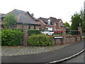
Foxhills Close, Stretton
One of many 'closes' in this relatively newly-developed housing estate.
Image: © M J Richardson
Taken: 14 May 2011
0.06 miles
3
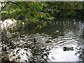
Pond at Pewterspear
One of the many ponds left untouched around this area of New Town development to Warrington's south. SJ62038312.
Image: © Keith Williamson
Taken: 9 Oct 2005
0.09 miles
4

Fungi
Fungi fruiting in grassland at Pewterspear, Appleton. SJ62018342.
Image: © Keith Williamson
Taken: 9 Oct 2005
0.12 miles
5
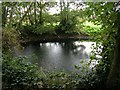
Pond at the Edge of the Wood
A small pond located at the edge of some woodland near Pewterspear, Appleton. SJ62288332.
Image: © Keith Williamson
Taken: 9 Oct 2005
0.12 miles
6
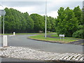
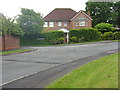
Pewterspear Green Road
At its roundabout junction with Longwood Road.
Image: © M J Richardson
Taken: 14 May 2011
0.13 miles
7
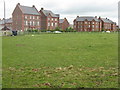
The end of Pewterspear Green Road
Pewterspear Green Road winds its way through a relatively new housing estate, and appears to terminate in the centre of a group of modern tenements.
Image: © M J Richardson
Taken: 14 May 2011
0.17 miles
8
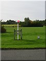
Pipes!
A marker post denoting the location of multiple pipelines at Pewterspear to the south of Warrington.
Image: © Keith Williamson
Taken: 9 Oct 2005
0.17 miles
9
The other side of Janus
The reverse face of Janus at Pewterspear, Appleton near Warrington. See accompanying submission for more detail. The straight line of the old Roman road out of Warrington (known to the Romans as Veratinum) can be seen here. now a public footpath. SJ61878342
Image: © Keith Williamson
Taken: 9 Oct 2005
0.18 miles
10
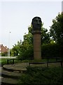
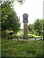
Janus
This bronze head depicting the Roman god Janus stands on a sandstone column at Pewterspear, Appleton to the south of Warrington. It was commissioned by the Commission for New Towns (Pewterspear is part of new town developments around Warrington) and was pruduced by Phil Bews and Diane Gorvin. It lies on the old Roman road running south from Warrington. SJ61878342.
Image: © Keith Williamson
Taken: 9 Oct 2005
0.18 miles