IMAGES TAKEN NEAR TO
Hobb Lane, WARRINGTON, WA4 5LS
Introduction
This page details the photographs taken nearby to Hobb Lane, WA4 5LS by members of the Geograph project.
The Geograph project started in 2005 with the aim of publishing, organising and preserving representative images for every square kilometre of Great Britain, Ireland and the Isle of Man.

There are currently over 7.5m images from over14,400 individuals and you can help contribute to the project by visiting https://www.geograph.org.uk
Image Map
Images are licensed for reuse under creativecommons.org/licenses/by-sa/2.0
Notes
- Clicking on the map will re-center to the selected point.
- The higher the marker number, the further away the image location is from the centre of the postcode.
Image Listing (5 Images Found)
Images are licensed for reuse under creativecommons.org/licenses/by-sa/2.0
Image
Details
Distance
4
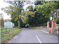
Junction of the A56 and Hobb Lane
Looking SW towards Daresbury
Image: © Alexander P Kapp
Taken: 27 Jan 2006
0.24 miles
5
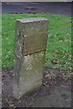
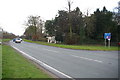
Old Milestone, Chester Road (was A56), between Daresbury and Walton
The milestone is located 200m South West of Hobb Lane on the North West side of the road on the wide grass verge in front of 'The Croft'. Metal plate attached to concrete post, erected by Chester & Frodsham turnpike trust in the 19th century.
Inscription reads:-
..........MILES
CHESTER, 16
FRODSHAM, 6
WARRINGTON, 3½
Milestone Society National ID: CH_CHWA16X
Image: © Stephan Charles
Taken: 2 Dec 2015
0.24 miles