IMAGES TAKEN NEAR TO
Firs Lane, WARRINGTON, WA4 5LQ
Introduction
This page details the photographs taken nearby to Firs Lane, WA4 5LQ by members of the Geograph project.
The Geograph project started in 2005 with the aim of publishing, organising and preserving representative images for every square kilometre of Great Britain, Ireland and the Isle of Man.

There are currently over 7.5m images from over14,400 individuals and you can help contribute to the project by visiting https://www.geograph.org.uk
Image Map
Images are licensed for reuse under creativecommons.org/licenses/by-sa/2.0
Notes
- Clicking on the map will re-center to the selected point.
- The higher the marker number, the further away the image location is from the centre of the postcode.
Image Listing (6 Images Found)
Images are licensed for reuse under creativecommons.org/licenses/by-sa/2.0
Image
Details
Distance
1
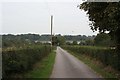
Hurst Farm entrance drive
A bit of careless map-reading led me up this (private) road. I didn't even notice Image, which was open, though a resident put me straight as I left. This is the view back down the drive, with Appleton Reservoir in the distance.
Image: © Dave Dunford
Taken: 19 Sep 2009
0.09 miles
2
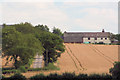
Hurst Farm viewed from Appleton Reservoir
Image: © Dave Currie
Taken: 23 Jul 2006
0.11 miles
4
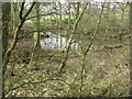
Pond at Hurst Farm
One of several in small patches of woodland in the area - small kettle holes?
Image: © M J Richardson
Taken: 23 Mar 2012
0.21 miles
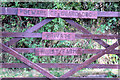
5
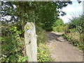
Delamere way marker post near Hurst Farm
Image: © Raymond Knapman
Taken: 27 Aug 2014
0.23 miles
6
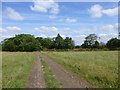
Delamere way approaches a copse near Hurst Farm
Image: © Raymond Knapman
Taken: 27 Aug 2014
0.23 miles