IMAGES TAKEN NEAR TO
Park Lane, WARRINGTON, WA4 5LH
Introduction
This page details the photographs taken nearby to Park Lane, WA4 5LH by members of the Geograph project.
The Geograph project started in 2005 with the aim of publishing, organising and preserving representative images for every square kilometre of Great Britain, Ireland and the Isle of Man.

There are currently over 7.5m images from over14,400 individuals and you can help contribute to the project by visiting https://www.geograph.org.uk
Image Map
Images are licensed for reuse under creativecommons.org/licenses/by-sa/2.0
Notes
- Clicking on the map will re-center to the selected point.
- The higher the marker number, the further away the image location is from the centre of the postcode.
Image Listing (4 Images Found)
Images are licensed for reuse under creativecommons.org/licenses/by-sa/2.0
Image
Details
Distance
1
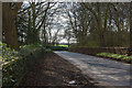
Park Lane
Taken across the road from the car park which,incredibly, closes and has its gate locked at 3:45 in the afternoon
Image: © Ian Greig
Taken: 19 Apr 2013
0.10 miles
2
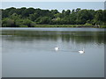
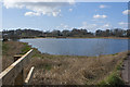
Swans on Appleton Reservoir, Higher Walton
Appleton Reservoir was built in the shallow valley above Walton Hall to supply the estate with water.
Image: © Sue Adair
Taken: 24 Jun 2020
0.14 miles
4
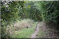
Permitted path around Appleton Reservoir
This permitted path allows a pleasant circuit of Appleton Reservoir. Sadly a teenager drowned while swimming in the reservoir in the summer of 2009.
Image: © Dave Dunford
Taken: 19 Sep 2009
0.24 miles