IMAGES TAKEN NEAR TO
Firs Lane, WARRINGTON, WA4 5LD
Introduction
This page details the photographs taken nearby to Firs Lane, WA4 5LD by members of the Geograph project.
The Geograph project started in 2005 with the aim of publishing, organising and preserving representative images for every square kilometre of Great Britain, Ireland and the Isle of Man.

There are currently over 7.5m images from over14,400 individuals and you can help contribute to the project by visiting https://www.geograph.org.uk
Image Map
Images are licensed for reuse under creativecommons.org/licenses/by-sa/2.0
Notes
- Clicking on the map will re-center to the selected point.
- The higher the marker number, the further away the image location is from the centre of the postcode.
Image Listing (8 Images Found)
Images are licensed for reuse under creativecommons.org/licenses/by-sa/2.0
Image
Details
Distance
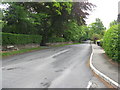
1
The well on Firs Lane at Hill Cliffe
Image: © Raymond Knapman
Taken: 27 Aug 2014
0.12 miles
2
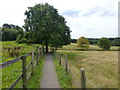
Mersey Valley Trail
Above Hillfoot Farm with a wide view over Warrington. The Trail leaves the woodland here and shortly afterwards joins the footpath from Hillfoot Farm en route for Foxes Covert Cemetery.
Image: © Dave Dunford
Taken: 19 Sep 2009
0.15 miles
3
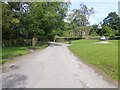
Housing at Hill Cliffe
View from Firs Lane
Image: © Raymond Knapman
Taken: 27 Aug 2014
0.15 miles
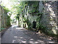
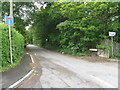
4
The Mersey Valley Trail at Hill Cliffe
Image: © Raymond Knapman
Taken: 27 Aug 2014
0.18 miles
6
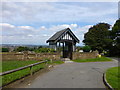
Lych gate at Hill Cliffe Cemetery
From here there are broad views over the Mersey and Warrington.
Image: © Raymond Knapman
Taken: 27 Aug 2014
0.22 miles
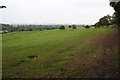
7
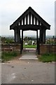
Foxes Covert Cemetery
Extensive cemetery with a wide view over the Mersey valley.
Image: © Dave Dunford
Taken: 19 Sep 2009
0.22 miles