IMAGES TAKEN NEAR TO
London Road, WARRINGTON, WA4 5HR
Introduction
This page details the photographs taken nearby to London Road, WA4 5HR by members of the Geograph project.
The Geograph project started in 2005 with the aim of publishing, organising and preserving representative images for every square kilometre of Great Britain, Ireland and the Isle of Man.

There are currently over 7.5m images from over14,400 individuals and you can help contribute to the project by visiting https://www.geograph.org.uk
Image Map
Images are licensed for reuse under creativecommons.org/licenses/by-sa/2.0
Notes
- Clicking on the map will re-center to the selected point.
- The higher the marker number, the further away the image location is from the centre of the postcode.
Image Listing (8 Images Found)
Images are licensed for reuse under creativecommons.org/licenses/by-sa/2.0
Image
Details
Distance
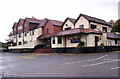
2

London Road follows the course of a Roman road
Image: © Ian Greig
Taken: 10 Apr 2015
0.07 miles
3
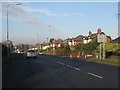
London Road (A49) at Dudlow Green Road
Image: © Peter Whatley
Taken: 17 Jan 2012
0.12 miles
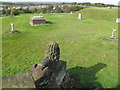
4

High Warren
Local authority highpoint for devotees of http://www.cohp.org . Monument on a reservoir in the middle of Warrington Golf Club's course.
Image: © Richard Webb
Taken: 12 Mar 2004
0.13 miles
5
Appleton Park
Parked on side street and walked through golf course car park, 1 section of the railing broken so no problems with access, good views to distant power station.
Warrington current county/UA top on Warrington Golf Course.
Name: Appleton Park
Hill number: 5557
Height: 105m / 344ft
Area: 36: Lancashire, Cheshire & the Southern Pennines
Class: CoU
Grid ref: SJ 61405 84258
Summit feature: monument near trig pillar on top of covered reservoir
Drop: 51m
Col: 54m SJ725804
Image: © Rude Health
Taken: 7 Oct 2009
0.14 miles
6
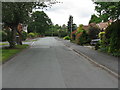
Dudlow's Green Road
Looking west to London Road [A49].
Image: © M J Richardson
Taken: 14 May 2011
0.17 miles
7

Beechways, from Dudlow Green Road
One of several tree-themed streetnames in the area.
Image: © M J Richardson
Taken: 14 May 2011
0.17 miles
8
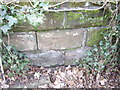
Cut Mark: Quarry Lane, Appleton
OS Cut Mark on the roadside wall of Quarry Lane, Appleton. Number B11049 on the Benchmark Database, see http://www.bench-marks.org.uk/bm37398
Image: © VBForever
Taken: 25 Mar 2011
0.25 miles